IMAGES TAKEN NEAR TO
Grange Close, SOUTHPORT, PR9 8SD
Introduction
This page details the photographs taken nearby to Grange Close, PR9 8SD by members of the Geograph project.
The Geograph project started in 2005 with the aim of publishing, organising and preserving representative images for every square kilometre of Great Britain, Ireland and the Isle of Man.

There are currently over 7.5m images from over14,400 individuals and you can help contribute to the project by visiting https://www.geograph.org.uk
Image Map
Images are licensed for reuse under creativecommons.org/licenses/by-sa/2.0
Notes
- Clicking on the map will re-center to the selected point.
- The higher the marker number, the further away the image location is from the centre of the postcode.
Image Listing (13 Images Found)
Images are licensed for reuse under creativecommons.org/licenses/by-sa/2.0
Image
Details
Distance
2
Cycle path beside Southport New Road (A565)
Heading north west.
Don't forget to duck.
Image: © JThomas
Taken: 11 Oct 2014
0.08 miles
3
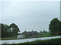
Bungalow in Gravel Lane seen from the A565
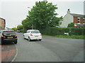
Image: © Peter Robinson
Taken: 24 May 2012
0.11 miles
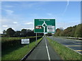
5
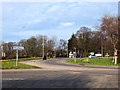
Roundabout at the junction of Southport New Road and Gravel Lane
Image: © Gary Rogers
Taken: 8 Apr 2018
0.12 miles
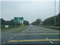
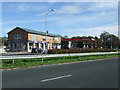
6
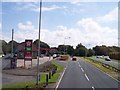
Southport New Road at Banks
New roundabout in view ahead of garage
Image: © Raymond Knapman
Taken: 8 Aug 2012
0.12 miles
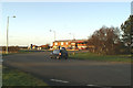
8
Service station off Southport New Road (A565)
Image: © JThomas
Taken: 11 Oct 2014
0.15 miles
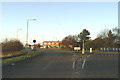
9
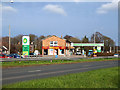
BP Petrol Station on Southport New Road
Price 119.9p per litre for unleaded.
A branch of Millercare mobility specialists is also on this site
Image: © Gary Rogers
Taken: 8 Apr 2018
0.15 miles