IMAGES TAKEN NEAR TO
Holmdale Avenue, SOUTHPORT, PR9 8PS
Introduction
This page details the photographs taken nearby to Holmdale Avenue, PR9 8PS by members of the Geograph project.
The Geograph project started in 2005 with the aim of publishing, organising and preserving representative images for every square kilometre of Great Britain, Ireland and the Isle of Man.

There are currently over 7.5m images from over14,400 individuals and you can help contribute to the project by visiting https://www.geograph.org.uk
Image Map (Loading...)


Getting Data...Please wait
Leaflet Map data © OpenStreetMap
Images are licensed for reuse under creativecommons.org/licenses/by-sa/2.0
Notes
- Clicking on the map will re-center to the selected point.
- The higher the marker number, the further away the image location is from the centre of the postcode.
Image Listing (18 Images Found)
Images are licensed for reuse under creativecommons.org/licenses/by-sa/2.0
Image
Details
Distance
1
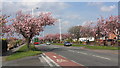
Cherry Blossom Time
For a couple of weeks in late April Preston New Road becomes even more attractive when the ornamental cherry trees come into bloom
Image: © K A
Taken: 23 Apr 2012
0.11 miles
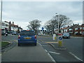
10
Junction of Rufford Road and North Road, Crossens
Image: © Gary Rogers
Taken: 8 Apr 2018
0.23 miles