IMAGES TAKEN NEAR TO
Bartons Close, SOUTHPORT, PR9 8NF
Introduction
This page details the photographs taken nearby to Bartons Close, PR9 8NF by members of the Geograph project.
The Geograph project started in 2005 with the aim of publishing, organising and preserving representative images for every square kilometre of Great Britain, Ireland and the Isle of Man.

There are currently over 7.5m images from over14,400 individuals and you can help contribute to the project by visiting https://www.geograph.org.uk
Image Map (Loading...)


Getting Data...Please wait
Leaflet Map data © OpenStreetMap
Images are licensed for reuse under creativecommons.org/licenses/by-sa/2.0
Notes
- Clicking on the map will re-center to the selected point.
- The higher the marker number, the further away the image location is from the centre of the postcode.
Image Listing (27 Images Found)
Images are licensed for reuse under creativecommons.org/licenses/by-sa/2.0
Image
Details
Distance
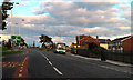
1
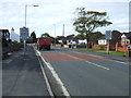
Entering Crossens
Heading west on Water Lane (A565).
Image: © JThomas
Taken: 11 Oct 2014
0.07 miles
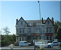
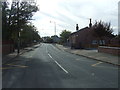
6
Preston New Road, Crossens
Preston New Road (A565), approaching the roundabout at the junction with Rufford Road (B5244).
Image: © David Dixon
Taken: 25 Sep 2010
0.14 miles
7
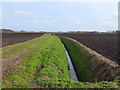
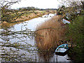
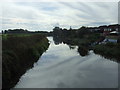
Drainage ditch near Sandy Bridge, Crossens
Image: © Gary Rogers
Taken: 8 Apr 2018
0.15 miles
8
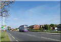
Crossens terminus
The Arriva bus on the A565 Preston New Road has just completed the route #47 service from Liverpool.
Image: © Gerald England
Taken: 13 May 2022
0.15 miles
10
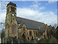
St John's church, Crossens, Southport
1885, architect Chorley & Connon.
Image: © S Parish
Taken: 11 Mar 2008
0.18 miles