IMAGES TAKEN NEAR TO
Banks Road, SOUTHPORT, PR9 8JL
Introduction
This page details the photographs taken nearby to Banks Road, PR9 8JL by members of the Geograph project.
The Geograph project started in 2005 with the aim of publishing, organising and preserving representative images for every square kilometre of Great Britain, Ireland and the Isle of Man.

There are currently over 7.5m images from over14,400 individuals and you can help contribute to the project by visiting https://www.geograph.org.uk
Image Map
Images are licensed for reuse under creativecommons.org/licenses/by-sa/2.0
Notes
- Clicking on the map will re-center to the selected point.
- The higher the marker number, the further away the image location is from the centre of the postcode.
Image Listing (22 Images Found)
Images are licensed for reuse under creativecommons.org/licenses/by-sa/2.0
Image
Details
Distance
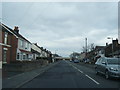
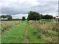
2
The last houses in Banks Road
We are already outside Sefton and in West Lancashire. At this point the road becomes Ralph's Wife's Lane, as if to make a point.
Image: © Keith Edkins
Taken: 9 Mar 2018
0.04 miles
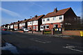
3
Thereby hangs a tale...
Actually I found there are several tales attempting to explain this road name. Some involve smuggling. The prosaic, and therefore most likely, one, is that Ralph divorced his wife with a settlement involving a plot of land at the ends of this lane.
Image: © Keith Edkins
Taken: 9 Mar 2018
0.06 miles
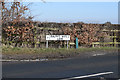
5
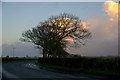
Ralph's Wife Lane, Banks
Winter trees at dusk.
Image: © Mike Pennington
Taken: 18 Nov 2015
0.09 miles
6
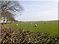
Sheep Grazing
Sheep grazing a large flat field south of Ralph's Wife's Lane.
Image: © Rude Health
Taken: 22 Mar 2015
0.10 miles
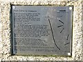
8
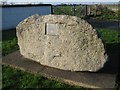
Erratic Boulder
Dug out of the ground when Crossens Pumping Station was built Image
Image: © K A
Taken: 28 Nov 2009
0.12 miles
9
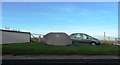
Erratic Boulder at Crossens
Unearthed when the nearby pumping station was built - geologists identified it as originating in Dumries Scotland and carried by glacial action in the last ice age.
Image: © Anthony Parkes
Taken: 30 Nov 2013
0.12 miles