IMAGES TAKEN NEAR TO
Neales Fold, SOUTHPORT, PR9 8HW
Introduction
This page details the photographs taken nearby to Neales Fold, PR9 8HW by members of the Geograph project.
The Geograph project started in 2005 with the aim of publishing, organising and preserving representative images for every square kilometre of Great Britain, Ireland and the Isle of Man.

There are currently over 7.5m images from over14,400 individuals and you can help contribute to the project by visiting https://www.geograph.org.uk
Image Map (Loading...)


Getting Data...Please wait
Leaflet Map data © OpenStreetMap
Images are licensed for reuse under creativecommons.org/licenses/by-sa/2.0
Notes
- Clicking on the map will re-center to the selected point.
- The higher the marker number, the further away the image location is from the centre of the postcode.
Image Listing (24 Images Found)
Images are licensed for reuse under creativecommons.org/licenses/by-sa/2.0
Image
Details
Distance
2
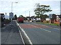
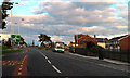
Entering Crossens
Heading west on Water Lane (A565).
Image: © JThomas
Taken: 11 Oct 2014
0.13 miles
3
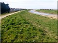
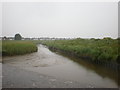
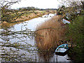
Footpath On West Bank Of Back Drain
A view along the footpath on the west bank of back Drain, Crossens.
Image: © Rude Health
Taken: 22 Mar 2015
0.13 miles
4
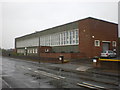
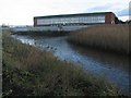
Crossens Pumping Station on Banks Road
Pumps the water from The Sluice, Back Drain and Three Pools Waterway into the sea
Image: © Alexander P Kapp
Taken: 17 Jun 2009
0.14 miles
5
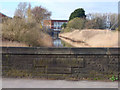
Crossens Pool
This is where the water is pumped into from The Sluice, Back Drain and Three Pools Waterway, these three drains are the main drainage ditches for the area to the east of Southport
Image: © Alexander P Kapp
Taken: 17 Jun 2009
0.14 miles
6
Crossens Pumping Station
The pumping station drains the mosslands and what was once Martin Mere which was England's largest lake. TheSluice is full of fresh water with the pumps busy after recent heavy rainfall
Image: © K A
Taken: 28 Nov 2009
0.14 miles
8
Preston New Road, Crossens
Preston New Road (A565), approaching the roundabout at the junction with Rufford Road (B5244).
Image: © David Dixon
Taken: 25 Sep 2010
0.15 miles
10
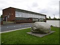
Criffel Granite Erratic at Crossens
This granite erratic was found when the pumping station was built in 1959. The boulder was transported here from the Dumfries region during the ice age.
Image: © Gary Rogers
Taken: 9 May 2010
0.15 miles