IMAGES TAKEN NEAR TO
Eversham Close, SOUTHPORT, PR9 8FQ
Introduction
This page details the photographs taken nearby to Eversham Close, PR9 8FQ by members of the Geograph project.
The Geograph project started in 2005 with the aim of publishing, organising and preserving representative images for every square kilometre of Great Britain, Ireland and the Isle of Man.

There are currently over 7.5m images from over14,400 individuals and you can help contribute to the project by visiting https://www.geograph.org.uk
Image Map (Loading...)


Getting Data...Please wait
Leaflet Map data © OpenStreetMap
Images are licensed for reuse under creativecommons.org/licenses/by-sa/2.0
Notes
- Clicking on the map will re-center to the selected point.
- The higher the marker number, the further away the image location is from the centre of the postcode.
Image Listing (10 Images Found)
Images are licensed for reuse under creativecommons.org/licenses/by-sa/2.0
Image
Details
Distance
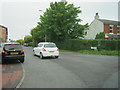
1
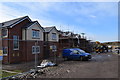
House building on Guinea Hall Lane
Twenty houses are currently under construction on the west side of Guinea Hall Lane.
Image: © Keith Edkins
Taken: 9 Mar 2018
0.06 miles
2
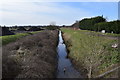
The Railway Drain
This drain follows the line of the West Lancashire Railway, which ran from Southport to Preston. Banks Station was here, on the other side of the road. The line was lifted in 1965. No charge for the traffic cone.
Image: © Keith Edkins
Taken: 9 Mar 2018
0.11 miles
3
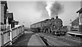
Banks Station, with Preston - Southport train
View eastwards, towards Preston; ex-Lancashire & Yorkshire (West Lancashire) Preston - Southport line, which was closed with the station on 7/9/64 - less than two weeks after this photograph. The train is the 17.59 from Preston, headed by LMS Fowler 2-6-4T No. 42369.
Image: © Ben Brooksbank
Taken: 26 Aug 1964
0.12 miles
4

To the rescue
A local resident putting a J. C. B. to good use after the biggest snow fall for nearly thirty years
Image: © K A
Taken: 18 Dec 2010
0.12 miles
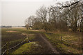
7

Former Railway Line
This view is looking along the trackbed of the former West Lancashire Railway line that ran from Southport to Preston which was closed as part of Dr. Beeching reorganisation of British Rail in 1964.
Image: © K A
Taken: 11 Sep 2009
0.24 miles
8
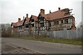
Greaves Hall Mansion
I see little point in making a comment on such a sad picture.
Image: © Anonymous
Taken: 27 Dec 2006
0.24 miles
9
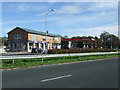
Service station off Southport New Road (A565)
Image: © JThomas
Taken: 11 Oct 2014
0.25 miles
10
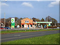
BP Petrol Station on Southport New Road
Price 119.9p per litre for unleaded.
A branch of Millercare mobility specialists is also on this site
Image: © Gary Rogers
Taken: 8 Apr 2018
0.25 miles