IMAGES TAKEN NEAR TO
Ralphs Wifes Lane, SOUTHPORT, PR9 8ER
Introduction
This page details the photographs taken nearby to Ralphs Wifes Lane, PR9 8ER by members of the Geograph project.
The Geograph project started in 2005 with the aim of publishing, organising and preserving representative images for every square kilometre of Great Britain, Ireland and the Isle of Man.

There are currently over 7.5m images from over14,400 individuals and you can help contribute to the project by visiting https://www.geograph.org.uk
Image Map (Loading...)


Getting Data...Please wait
Leaflet Map data © OpenStreetMap
Images are licensed for reuse under creativecommons.org/licenses/by-sa/2.0
Notes
- Clicking on the map will re-center to the selected point.
- The higher the marker number, the further away the image location is from the centre of the postcode.
Image Listing (34 Images Found)
Images are licensed for reuse under creativecommons.org/licenses/by-sa/2.0
Image
Details
Distance
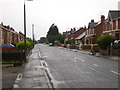
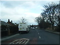
2
Ralph's Wife's Lane, Banks
It might almost be Spring!
Image: © Keith Edkins
Taken: 9 Mar 2018
0.03 miles
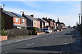
3
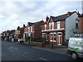
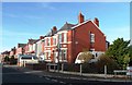
Houses on Ralph's Wife's Lane, Banks
Heading west.
Image: © JThomas
Taken: 22 Nov 2014
0.06 miles
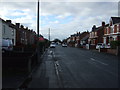
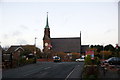
4
St. Stephen in the Banks
From Ralph's Wife's Lane
Image: © David Long
Taken: 7 Apr 2006
0.08 miles
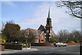
9
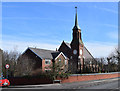
Church of St Stephen in the Banks
The village of Banks is thought to be named for a series of embankments built to restrain the River Ribble. It is clained that the local pronunciation is "Bonks".
Image: © Keith Edkins
Taken: 9 Mar 2018
0.13 miles
10
Banks Methodist Chapel, Church Lane, Banks
Image: © Mike Pennington
Taken: 18 Nov 2015
0.14 miles