IMAGES TAKEN NEAR TO
Rydings Lane, SOUTHPORT, PR9 8EB
Introduction
This page details the photographs taken nearby to Rydings Lane, PR9 8EB by members of the Geograph project.
The Geograph project started in 2005 with the aim of publishing, organising and preserving representative images for every square kilometre of Great Britain, Ireland and the Isle of Man.

There are currently over 7.5m images from over14,400 individuals and you can help contribute to the project by visiting https://www.geograph.org.uk
Image Map (Loading...)


Getting Data...Please wait
Leaflet Map data © OpenStreetMap
Images are licensed for reuse under creativecommons.org/licenses/by-sa/2.0
Notes
- Clicking on the map will re-center to the selected point.
- The higher the marker number, the further away the image location is from the centre of the postcode.
Image Listing (7 Images Found)
Images are licensed for reuse under creativecommons.org/licenses/by-sa/2.0
Image
Details
Distance
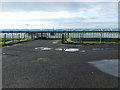
1

Fields and greenhouses north of Gorsey Lane, Banks
Image: © Mike Pennington
Taken: 7 Jul 2016
0.10 miles
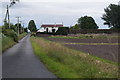
3
Flat farmland near Crossings Farm
Footpath off to the right.
Image: © JThomas
Taken: 22 Nov 2014
0.14 miles
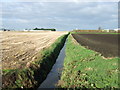
5
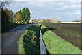
Drain beside lane
Looking north near Crossings Farm.
Image: © JThomas
Taken: 22 Nov 2014
0.16 miles
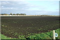
6
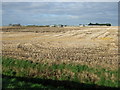
Stubble field off Gorsey Lane
Greenhouses in the distance.
Image: © JThomas
Taken: 22 Nov 2014
0.20 miles