IMAGES TAKEN NEAR TO
Westerdale Drive, SOUTHPORT, PR9 8DG
Introduction
This page details the photographs taken nearby to Westerdale Drive, PR9 8DG by members of the Geograph project.
The Geograph project started in 2005 with the aim of publishing, organising and preserving representative images for every square kilometre of Great Britain, Ireland and the Isle of Man.

There are currently over 7.5m images from over14,400 individuals and you can help contribute to the project by visiting https://www.geograph.org.uk
Image Map
Images are licensed for reuse under creativecommons.org/licenses/by-sa/2.0
Notes
- Clicking on the map will re-center to the selected point.
- The higher the marker number, the further away the image location is from the centre of the postcode.
Image Listing (4 Images Found)
Images are licensed for reuse under creativecommons.org/licenses/by-sa/2.0
Image
Details
Distance
1
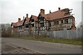
Greaves Hall Mansion
I see little point in making a comment on such a sad picture.
Image: © Anonymous
Taken: 27 Dec 2006
0.13 miles
4
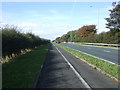
Cycle path beside Southport New Road (A565)
Heading north west.
Image: © JThomas
Taken: 11 Oct 2014
0.24 miles