IMAGES TAKEN NEAR TO
Wyke Wood Lane, SOUTHPORT, PR9 8AW
Introduction
This page details the photographs taken nearby to Wyke Wood Lane, PR9 8AW by members of the Geograph project.
The Geograph project started in 2005 with the aim of publishing, organising and preserving representative images for every square kilometre of Great Britain, Ireland and the Isle of Man.

There are currently over 7.5m images from over14,400 individuals and you can help contribute to the project by visiting https://www.geograph.org.uk
Image Map (Loading...)


Getting Data...Please wait
Leaflet Map data © OpenStreetMap
Images are licensed for reuse under creativecommons.org/licenses/by-sa/2.0
Notes
- Clicking on the map will re-center to the selected point.
- The higher the marker number, the further away the image location is from the centre of the postcode.
Image Listing (12 Images Found)
Images are licensed for reuse under creativecommons.org/licenses/by-sa/2.0
Image
Details
Distance
1

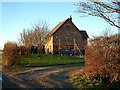
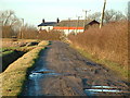
Drainage Ditch and Midge Hall Farm
Substantial Drainage Ditch and Pipeline Indicator Post looking towards Midge Hall Farm
Image: © Michael Alley
Taken: 24 Feb 2012
0.02 miles
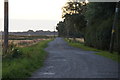
3
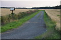
Track off Wyke Wood Lane, Martin Mere
Image: © Mike Pennington
Taken: 7 Aug 2015
0.11 miles
5
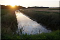
Old Top Cut, Martin Mere, at sunset
One of many ditches that drain Martin Mere and the SW Lancashire mosses.
Image: © Mike Pennington
Taken: 7 Aug 2015
0.15 miles
7

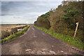
Wyke Wood Lane, Martin Mere, at sunset
Image: © Mike Pennington
Taken: 7 Aug 2015
0.18 miles
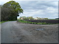
10

Covert corner of Caunces Road and Midge Hall Lane
Image: © Michael Alley
Taken: 24 Feb 2012
0.21 miles