IMAGES TAKEN NEAR TO
Abrams Fold, SOUTHPORT, PR9 8AL
Introduction
This page details the photographs taken nearby to Abrams Fold, PR9 8AL by members of the Geograph project.
The Geograph project started in 2005 with the aim of publishing, organising and preserving representative images for every square kilometre of Great Britain, Ireland and the Isle of Man.

There are currently over 7.5m images from over14,400 individuals and you can help contribute to the project by visiting https://www.geograph.org.uk
Image Map (10 Images)


Getting Data...Please wait
Leaflet Map data © OpenStreetMap
Images are licensed for reuse under creativecommons.org/licenses/by-sa/2.0
Notes
- Clicking on the map will re-center to the selected point.
- The higher the marker number, the further away the image location is from the centre of the postcode.
Image Listing (10 Images Found)
Images are licensed for reuse under creativecommons.org/licenses/by-sa/2.0
Image
Details
Distance
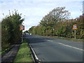
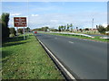
1

Southport New Road (A565), Banks
The start of the dual carriageway section.
Image: © David Dixon
Taken: 25 Sep 2010
0.08 miles
2

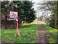
Disused Railway Trackbed
The trackbed of the West Lancashire Railway line that ran from Preston to Southport which closed to all traffic in 1964.
Image: © K A
Taken: 19 Aug 2011
0.08 miles
3
Cut through from Southport New Road to Gravel Lane
Image: © Gary Rogers
Taken: 8 Apr 2018
0.12 miles
4
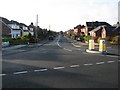
Station Road
Banks is one of the many places the now has a Station Road but no station. In actual fact the station was situated on Hoole Lane immediately behind where I was standing to take the photo. Prior to the railway opening the road was called Brick Kiln Lane as there was a brick croft there.
Image: © K A
Taken: 20 Nov 2009
0.15 miles
5
Station Road from Ralph's Wife's Lane, Banks
Image: © Mike Pennington
Taken: 7 Jul 2016
0.16 miles

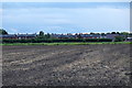
7
Southport New Road (A565)
Heading north west.
Image: © JThomas
Taken: 11 Oct 2014
0.17 miles

9
Southport New Road (A565)
Heading north west.
Image: © JThomas
Taken: 11 Oct 2014
0.25 miles
10
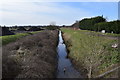
The Railway Drain
This drain follows the line of the West Lancashire Railway, which ran from Southport to Preston. Banks Station was here, on the other side of the road. The line was lifted in 1965. No charge for the traffic cone.
Image: © Keith Edkins
Taken: 9 Mar 2018
0.25 miles