IMAGES TAKEN NEAR TO
Mill Lane, SOUTHPORT, PR9 7PL
Introduction
This page details the photographs taken nearby to Mill Lane, PR9 7PL by members of the Geograph project.
The Geograph project started in 2005 with the aim of publishing, organising and preserving representative images for every square kilometre of Great Britain, Ireland and the Isle of Man.

There are currently over 7.5m images from over14,400 individuals and you can help contribute to the project by visiting https://www.geograph.org.uk
Image Map
Images are licensed for reuse under creativecommons.org/licenses/by-sa/2.0
Notes
- Clicking on the map will re-center to the selected point.
- The higher the marker number, the further away the image location is from the centre of the postcode.
Image Listing (19 Images Found)
Images are licensed for reuse under creativecommons.org/licenses/by-sa/2.0
Image
Details
Distance
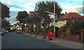
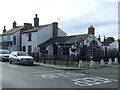
1
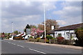
Cottages on the east side of Mill Lane, Churchtown
Image: © K A
Taken: 7 May 2013
0.02 miles
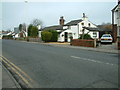
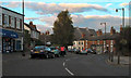
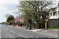
3
Mill Lane/Roe Lane (A5267) Junction
Traffic island at the junction of Mill Lane and Roe Lane.
Image: © David Dixon
Taken: 25 Sep 2010
0.11 miles
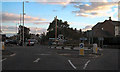
6
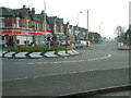
Island
View looking south towards High Park
Image: © Peter Hodge
Taken: 22 Jan 2006
0.14 miles
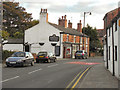
8
Churchgate, Southport
Churchgate, approaching the junction with Bibby Road.
Image: © David Dixon
Taken: 25 Sep 2010
0.16 miles
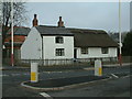
10
The Old Forge, Churchtown
On Botanic Road.
Image: © JThomas
Taken: 11 Oct 2014
0.18 miles