IMAGES TAKEN NEAR TO
Botanic Gardens, SOUTHPORT, PR9 7NB
Introduction
This page details the photographs taken nearby to Botanic Gardens, PR9 7NB by members of the Geograph project.
The Geograph project started in 2005 with the aim of publishing, organising and preserving representative images for every square kilometre of Great Britain, Ireland and the Isle of Man.

There are currently over 7.5m images from over14,400 individuals and you can help contribute to the project by visiting https://www.geograph.org.uk
Image Map (Loading...)


Getting Data...Please wait
Leaflet Map data © OpenStreetMap
Images are licensed for reuse under creativecommons.org/licenses/by-sa/2.0
Notes
- Clicking on the map will re-center to the selected point.
- The higher the marker number, the further away the image location is from the centre of the postcode.
Image Listing (38 Images Found)
Images are licensed for reuse under creativecommons.org/licenses/by-sa/2.0
Image
Details
Distance
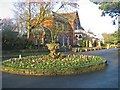
1
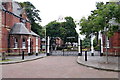
Entrance to Churchtown Botanic Gardens, Southport
Image: © Mike Pennington
Taken: 8 Jul 2016
0.01 miles
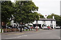
2
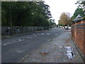
Bankfield Lane, Churchtown
The B5244 heading west.
Image: © JThomas
Taken: 11 Oct 2014
0.02 miles
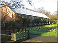
3
Southport Botanic Gardens
The Museum in Southport's Botanic Gardens
Image: © K A
Taken: 12 Dec 2009
0.03 miles
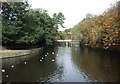
5
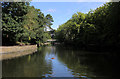
The Lake, Botanic Gardens in Churchtown
Image: © Chris Heaton
Taken: 22 Jul 2019
0.06 miles
6
The Fernery
The fernery in the Botanic Gardens in Southport. The gardens were laid out in 1874 and remain in their original Victorian layout
Image: © K A
Taken: 12 Dec 2009
0.06 miles
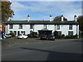
7
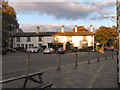
The Hesketh Arms
Sally's Lane/Botanic Road, Churchtown.
Image: © David Dixon
Taken: 25 Sep 2010
0.07 miles
8
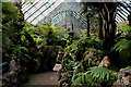
Inside The Fernery, Botanic Gardens in Churchtown
Hot, humid and Steamy.
Image: © Chris Heaton
Taken: 22 Jul 2019
0.07 miles