IMAGES TAKEN NEAR TO
Hawesside Street, SOUTHPORT, PR9 0TN
Introduction
This page details the photographs taken nearby to Hawesside Street, PR9 0TN by members of the Geograph project.
The Geograph project started in 2005 with the aim of publishing, organising and preserving representative images for every square kilometre of Great Britain, Ireland and the Isle of Man.

There are currently over 7.5m images from over14,400 individuals and you can help contribute to the project by visiting https://www.geograph.org.uk
Image Map (Loading...)


Getting Data...Please wait
Leaflet Map data © OpenStreetMap
Images are licensed for reuse under creativecommons.org/licenses/by-sa/2.0
Notes
- Clicking on the map will re-center to the selected point.
- The higher the marker number, the further away the image location is from the centre of the postcode.
Image Listing (155 Images Found)
Images are licensed for reuse under creativecommons.org/licenses/by-sa/2.0
Image
Details
Distance
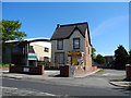
1
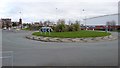
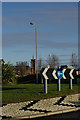
Roundabout at Derby Road
This large roundabout at the top of Derby road manages the traffic volume using the Asda superstore.
Image: © Peter Mackenzie
Taken: 16 Mar 2017
0.05 miles
2
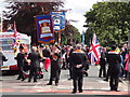
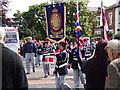
Getting ready for the march
Annual Orangemen's Day Parade in Southport, 12 July 2012.
Image: © Bryan Pready
Taken: 12 Jul 2012
0.05 miles
3
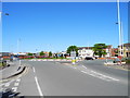
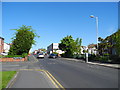
Derby Road , Southport
Approaching the roundabout with London Street.
Image: © John Topping
Taken: 25 May 2013
0.06 miles
5
The parade is underway
Annual Orangemen's Day Parade, 12 July 2012
Image: © Bryan Pready
Taken: 12 Jul 2012
0.06 miles
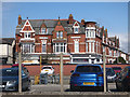
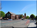
6
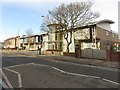
Derby Road, Southport
Looking towards Derby Road from the ASDA roundabout; the 'church' in the distance was formerly St Mark's Methodist Church but is now a medical centre.
Image: © Stephen McKay
Taken: 10 Dec 2008
0.07 miles
7
Southport College, Mornington Road, Southport
One of the buildings which make up the campus of Southport college. This one is on the north eastern side of Mornington Road.
Image: © Graham Robson
Taken: 24 Mar 2018
0.09 miles
8
Scarisbrick Street/Mornington Road junction, Southport
Heading northwest towards Union Street.
Image: © John Topping
Taken: 25 May 2013
0.10 miles
9
Parenting 2000 Children's Centre, Southport
Mornington Road.
Image: © John Topping
Taken: 25 May 2013
0.10 miles
10
Derby Road, Southport
At the junction with Mornington Road (left) and Kensington Road (right).
Image: © John Topping
Taken: 25 May 2013
0.10 miles