IMAGES TAKEN NEAR TO
Kensington Road, SOUTHPORT, PR9 0RT
Introduction
This page details the photographs taken nearby to Kensington Road, PR9 0RT by members of the Geograph project.
The Geograph project started in 2005 with the aim of publishing, organising and preserving representative images for every square kilometre of Great Britain, Ireland and the Isle of Man.

There are currently over 7.5m images from over14,400 individuals and you can help contribute to the project by visiting https://www.geograph.org.uk
Image Map (Loading...)


Getting Data...Please wait
Leaflet Map data © OpenStreetMap
Images are licensed for reuse under creativecommons.org/licenses/by-sa/2.0
Notes
- Clicking on the map will re-center to the selected point.
- The higher the marker number, the further away the image location is from the centre of the postcode.
Image Listing (52 Images Found)
Images are licensed for reuse under creativecommons.org/licenses/by-sa/2.0
Image
Details
Distance
1
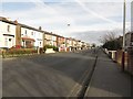
Kensington Road, Southport
A residential street close to the town centre.
Image: © Graham Robson
Taken: 24 Mar 2018
0.03 miles
2
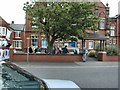
Southport Carnival
Carnival float from Arden College on Derby Road leaving to join the procession.
Image: © Gerald England
Taken: 25 Jun 2000
0.06 miles
3
Derby Road
Derby Road, Southport as a carnival float is leaving Arden College.
Image: © Gerald England
Taken: 25 Jun 2000
0.06 miles
4
Arden College
Former Methodist Church on Derby Road, now a Further Education College for Young Adults with Learning Difficulties and Disabilities.
Image: © Gerald England
Taken: 25 Jun 2000
0.06 miles
5
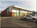
Stores at C12 Shopping Park, Southport
A row of 3 small retail units in the C12 Shopping Park close to Southport town centre. This small block contains branches of Mountain Warehouse, Costa Coffee and a still empty unit.
Image: © Graham Robson
Taken: 24 Mar 2018
0.07 miles
6
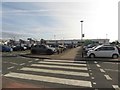
C12 Retail Park, Southport
Looking across the car park towards the main block of shops in the C12 Retail Park in Southport. The largest store in the development is occupied by ASDA. Among the other stores in this photo are Boots and Poundland.
Image: © Graham Robson
Taken: 24 Mar 2018
0.07 miles
7
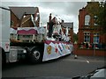
Southport Carnival
Carnival float leaving Arden College on Derby Road.
Image: © Gerald England
Taken: 25 Jun 2000
0.07 miles
8
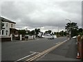
Derby Road, Southport
At the junction with Mornington Road (left) and Kensington Road (right).
Image: © John Topping
Taken: 25 May 2013
0.07 miles
9
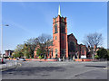
St Mark's Methodist Church, Southport
The former St Mark's Methodist Church, at the corner of Church Street and Derby Street is a Grade II Listed Building (http://www.britishlistedbuildings.co.uk/en-478964-st-marks-methodist-church-southport ) dating from around 1905. Since 2005, it has been in use as "St Mark's Medical Centre and Pharmacy" http://www.merseydoctors.nhs.uk/stmarks/practice/index.htm ).
Image: © David Dixon
Taken: 9 Apr 2011
0.08 miles
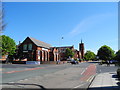
10
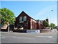
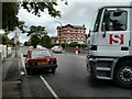
Shoreline Church, Southport
Situated on the corner of Mornington Road and Derby Road.
Image: © John Topping
Taken: 25 May 2013
0.08 miles