IMAGES TAKEN NEAR TO
Johnson Street, SOUTHPORT, PR9 0BQ
Introduction
This page details the photographs taken nearby to Johnson Street, PR9 0BQ by members of the Geograph project.
The Geograph project started in 2005 with the aim of publishing, organising and preserving representative images for every square kilometre of Great Britain, Ireland and the Isle of Man.

There are currently over 7.5m images from over14,400 individuals and you can help contribute to the project by visiting https://www.geograph.org.uk
Image Map (155 Images)


Getting Data...Please wait
Leaflet Map data © OpenStreetMap
Images are licensed for reuse under creativecommons.org/licenses/by-sa/2.0
Notes
- Clicking on the map will re-center to the selected point.
- The higher the marker number, the further away the image location is from the centre of the postcode.
Image Listing (155 Images Found)
Images are licensed for reuse under creativecommons.org/licenses/by-sa/2.0
Image
Details
Distance
1

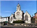
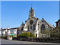
Church of St Marie on the Sands
The original church of St Marie on the Sands in Seabank Road was designed by A.W.N. Pugin. This small Roman Catholic church, opened in 1841, was enlarged and practically rebuilt in 1875 due to the increase in population following the arrival of the railway.
For sketch of the original church and further info:
http://www.stmariessouthport.org.uk/index_files/ChurchHistory.htm
Image: © Sue Adair
Taken: 23 Jul 2010
0.04 miles
2
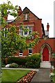
St Marie's Home for Retired Priests, Southport
St Marie’s originally became known as ‘St Marie’s on the Sands’ because it was actually built on the sand of Southport. In July 1840 the foundation stone was laid. Two Schools and Presbytery were later erected then the new school and convent were opened in 1876. St Marie’s school eventually closed in April 1968. Homes for retired priests were created from the old presbytery and parish hall, the old convent became the Parish House (the place where the Parish priest lives). Later the old school/parish centre became the ‘Marian Centre for Evangelisation.
Image: © Matt Harrop
Taken: 6 Jun 2015
0.05 miles
3
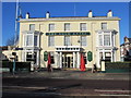
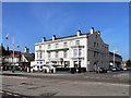
The Bold Hotel, 583 Lord Street, Southport
Looking across Lord Street towards The Bold Hotel, which is at the junction of Lord Street with Seabank Road. http://www.boldhotel.com/
Image: © John S Turner
Taken: 15 Jan 2013
0.06 miles
5
St Marie?s, Southport
Originally often referred to as ‘St Mary’s’ it became known as ‘St Marie’s on the Sands’ because it was actually built on the sand of Southport! The Church is dedicated to St Mary, the Mother of Jesus.
The original church of St Marie on the Sands, opened in 1841. It was practically rebuilt in 1875. (http://www.stmariessouthport.org.uk/index.htm - St Marie's church website)
Image: © David Dixon
Taken: 8 Apr 2011
0.06 miles
6
St Marie's, Southport
St Marie's was originally often referred to as ‘St Mary’s’; it became known as ‘St Marie’s on the Sands’ because it was actually built on the sand of Southport! The Church is dedicated to St Mary, the Mother of Jesus.
The original church of St Marie on the Sands opened in 1841. It was practically rebuilt in 1875. (http://www.stmariessouthport.org.uk/index.htm - St Marie's church website)
Image: © David Dixon
Taken: 9 Apr 2011
0.06 miles
7
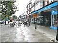
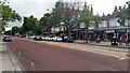
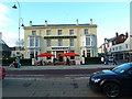
Southport revisited - Lord Street
The jewel in Southport's crown was always the superb broad shopping street of Lord Street. It retains some of its original elegance to this day. The pavement cafe may be by-product of the Covid pandemic of 2020-2021.
Image: © Oliver Dixon
Taken: 11 Aug 2021
0.07 miles
8
The Bold Hotel
The Bold Hotel, Lord Street, Southport.
Image: © David Dixon
Taken: 9 Apr 2011
0.07 miles
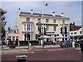
10
The Bold Hotel, Lord Street, Southport
Image: © Alexander P Kapp
Taken: 7 Dec 2012
0.07 miles