1
Scarisbrick New Road Baptist Church
Corner of Scarisbrick New Road and Southbank Road.
Image: © John Topping
Taken: 25 May 2013
0.10 miles
2
Eastbank Street roundabout
Roundabout with St. James Street (left), viewed from Southbank Road, Virignia Street and Scarisbrick New Road (right).
Image: © John Topping
Taken: 25 May 2013
0.11 miles
3
Roundabout on the A570, Southport
A roundabout at a junction between several mainly residential streets and the A570 close to the centre of Southport. Artwork resembling the shape of sails has been located in the centre of the roundabout.
Image: © Graham Robson
Taken: 24 Mar 2018
0.12 miles
4
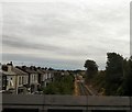
Rails to Liverpool
The line to Liverpool from Eastbank Street bridge.
Image: © Gerald England
Taken: 10 Jul 2009
0.12 miles
5
Ford, Southport Service Centre
Off Bridge Grove.
Image: © John Topping
Taken: 25 May 2013
0.12 miles
6
Southport Eastbank Street railway station (site), Merseyside
Opened in 1848 by the Liverpool, Crosby and Southport Railway, later part of the Lancashire & Yorkshire Railway, this short-lived station closed in 1851 when the line was extended into the current Southport (Chapel Street) railway station. At the time it existed, old maps show it was surrounded by fields.
View south east from Eastbank Street towards Birkdale and Liverpool. The former station-master's house is still extant to the right of the line with the red gable-end.
Image: © Nigel Thompson
Taken: 15 Feb 2023
0.12 miles
7
The Shakespeare, Southport
Corner of Virginia Street and Scarisbrick New Road.
Image: © John Topping
Taken: 25 May 2013
0.12 miles
8
Demolition of former pub, Scarisbrick New Road, Southport
The former Shakespeare pub on Scarisbrick New Road is in the process of being demolished.
Image] shows the pub 5 and a half years earlier when it was still open.
Image: © Graham Robson
Taken: 24 Mar 2018
0.12 miles
9
Eastbank Street, Southport
Looking towards the town centre; Southport is very flat and the road ascends a ramp in order to cross the Liverpool - Southport railway.
Image: © Stephen McKay
Taken: 10 Dec 2008
0.14 miles
10
Southport to Liverpool railway line
View southwest from Eastbank Street bridge.
Image: © John Topping
Taken: 25 May 2013
0.14 miles


