IMAGES TAKEN NEAR TO
Loxley Road, SOUTHPORT, PR8 6NP
Introduction
This page details the photographs taken nearby to Loxley Road, PR8 6NP by members of the Geograph project.
The Geograph project started in 2005 with the aim of publishing, organising and preserving representative images for every square kilometre of Great Britain, Ireland and the Isle of Man.

There are currently over 7.5m images from over14,400 individuals and you can help contribute to the project by visiting https://www.geograph.org.uk
Image Map (Loading...)


Getting Data...Please wait
Leaflet Map data © OpenStreetMap
Images are licensed for reuse under creativecommons.org/licenses/by-sa/2.0
Notes
- Clicking on the map will re-center to the selected point.
- The higher the marker number, the further away the image location is from the centre of the postcode.
Image Listing (6 Images Found)
Images are licensed for reuse under creativecommons.org/licenses/by-sa/2.0
Image
Details
Distance

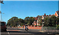
2

Junction between the A570 and Haig Avenue, Southport
Image: © nick macneill
Taken: 1 Sep 2011
0.18 miles
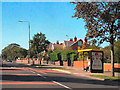
3
Scarisbrick New Road/Haig Avenue Junction, Southport
Image: © David Dixon
Taken: 25 Sep 2010
0.18 miles
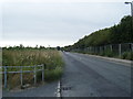
4
Scarisbrick New Road (A570)
Between King George V College and Haig Avenue.
Image: © David Dixon
Taken: 25 Sep 2010
0.20 miles
6
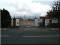
The old infirmary site
The site of the Southport Infirmary now demolished and awaiting redevelopment.
Image: © Michael Williamson
Taken: 28 Oct 2008
0.24 miles