IMAGES TAKEN NEAR TO
Ripon Close, SOUTHPORT, PR8 5PJ
Introduction
This page details the photographs taken nearby to Ripon Close, PR8 5PJ by members of the Geograph project.
The Geograph project started in 2005 with the aim of publishing, organising and preserving representative images for every square kilometre of Great Britain, Ireland and the Isle of Man.

There are currently over 7.5m images from over14,400 individuals and you can help contribute to the project by visiting https://www.geograph.org.uk
Image Map (Loading...)


Getting Data...Please wait
Leaflet Map data © OpenStreetMap
Images are licensed for reuse under creativecommons.org/licenses/by-sa/2.0
Notes
- Clicking on the map will re-center to the selected point.
- The higher the marker number, the further away the image location is from the centre of the postcode.
Image Listing (22 Images Found)
Images are licensed for reuse under creativecommons.org/licenses/by-sa/2.0
Image
Details
Distance


3
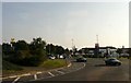
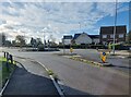
Meols Cop Roundabout
Just off the Meols Cop Roundabout on the A570 is the Tesco supermarket.
Image: © Gerald England
Taken: 26 Sep 2008
0.18 miles
4
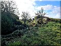
Fragment of railway embankment
Seen from the car park of Sure Store, this vestigial remnant appears to be the only remaining element of the Barton Branch railway at the Southport end of the line.
The railway was constructed in 1887 as part of the overly-ambitious Liverpool, Southport and Preston railway and ran on an embankment for a considerable distance from south of the scene here through to a point north of Peel Street, crossing the Scarisbrick road by a bridge at Kew Garden station. The line never realised its original expectations and in effect functioned mainly as a cul-de-sac line for the Altcar Bob railcar service to Barton (latterly known as Downholland) station.
Passenger services ceased in 1938 although the tracks were not removed until 1964. Apart from the fragment of embankment seen here, the whole of the embankment as far as Butts Lane junction as well as the bridge over the road has now been completely obliterated and built over by retail and trading estates.
Image: © Oliver Dixon
Taken: 22 Oct 2024
0.18 miles
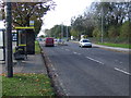
7
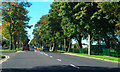
Scarisbrick New Road (A570), Southport
Scarisbrick New Road, passing Meols Park.
Image: © David Dixon
Taken: 25 Sep 2010
0.21 miles
8
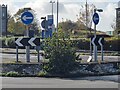
Foul Lane roundabout
Roundabout on the busy A570 which gives access to the various retail and trading estates in the vicinity. The roundabout stands on the site of a former railway bridge on the Barton Branch railway. In the background is the last remaining fragment of railway embankment Image For details about the railway at this point, see Image
Image: © Oliver Dixon
Taken: 22 Oct 2024
0.21 miles
9
Foul Lane roundabout
Roundabout on the busy A570 which gives access to the various retail and trading estates in the vicinity. The roundabout stands on the site of a former railway bridge on the Barton Branch railway with the site of Kew Gardens station (closed 1938) this side of the roundabout and just out of view to the right. In the background is the last remaining fragment of railway embankment Image The Old Duke public house stands on the far side of the main road.
Image: © Oliver Dixon
Taken: 22 Oct 2024
0.21 miles
10

Foul Lane roundabout
Roundabout on the busy A570 which gives access to the various retail and trading estates in the vicinity. The view is taken from the site of Kew Gardens station (closed 1938) on the Barton branch railway which spanned the road immediately this side of the roundabout. The bridge was approached on embankments on both side, now completely obliterated.
Image: © Oliver Dixon
Taken: 22 Oct 2024
0.21 miles