IMAGES TAKEN NEAR TO
Grove Terrace, SOUTHPORT, PR8 5NE
Introduction
This page details the photographs taken nearby to Grove Terrace, PR8 5NE by members of the Geograph project.
The Geograph project started in 2005 with the aim of publishing, organising and preserving representative images for every square kilometre of Great Britain, Ireland and the Isle of Man.

There are currently over 7.5m images from over14,400 individuals and you can help contribute to the project by visiting https://www.geograph.org.uk
Image Map (Loading...)


Getting Data...Please wait
Leaflet Map data © OpenStreetMap
Images are licensed for reuse under creativecommons.org/licenses/by-sa/2.0
Notes
- Clicking on the map will re-center to the selected point.
- The higher the marker number, the further away the image location is from the centre of the postcode.
Image Listing (17 Images Found)
Images are licensed for reuse under creativecommons.org/licenses/by-sa/2.0
Image
Details
Distance
1
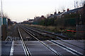
Railway at the level crossing at Aughton Road, Birkdale
Image: © Mike Pennington
Taken: 31 Dec 2013
0.03 miles
2
Aughton Road Level Crossing, Southport.
Image: © David Dixon
Taken: 25 Sep 2010
0.05 miles
3
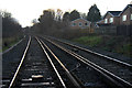
Railway at the level crossing at Aughton Road, Birkdale
Image: © Mike Pennington
Taken: 31 Dec 2013
0.07 miles
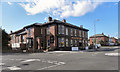
4
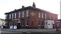
"The Blundell Arms" (Pub) 34 Upper Aughton Road, Birkdale, Southport, Lancashire-Merseyside PR8 5ND
Image: © Robert Wade
Taken: 27 Jan 2011
0.16 miles
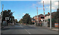
5
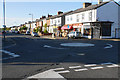
Mini roundabout on Aughton Road
A route leading to the centre of Southport.
Image: © Bill Boaden
Taken: 13 Sep 2019
0.17 miles
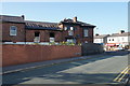
6
The Blundell Arms
At the corner of Aughton Road and Everton Road.
Image: © David Dixon
Taken: 25 Sep 2010
0.17 miles
7
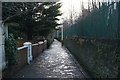
The Walk, Birkdale
Short pedestrian route between Aughton Road and Liverpool Road.
Image: © Mike Pennington
Taken: 31 Dec 2013
0.17 miles
8

Level crossing on Duke Street
The railway is the line between Southport and Liverpool.
Image: © Bill Boaden
Taken: 13 Sep 2019
0.17 miles
9
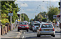
Traffic waiting at the level crossing in Duke Street
Image: © Ian Greig
Taken: 26 Aug 2016
0.17 miles
10
The Blundell Arms
The Everton Road side from which it can be seen that it is in a poor state of repair. There is an ongoing battle from locals who want to prevent the demolition of the site for housing.
Image: © Bill Boaden
Taken: 13 Sep 2019
0.18 miles