IMAGES TAKEN NEAR TO
Hares Lane, SOUTHPORT, PR8 5LG
Introduction
This page details the photographs taken nearby to Hares Lane, PR8 5LG by members of the Geograph project.
The Geograph project started in 2005 with the aim of publishing, organising and preserving representative images for every square kilometre of Great Britain, Ireland and the Isle of Man.

There are currently over 7.5m images from over14,400 individuals and you can help contribute to the project by visiting https://www.geograph.org.uk
Image Map (Loading...)


Getting Data...Please wait
Leaflet Map data © OpenStreetMap
Images are licensed for reuse under creativecommons.org/licenses/by-sa/2.0
Notes
- Clicking on the map will re-center to the selected point.
- The higher the marker number, the further away the image location is from the centre of the postcode.
Image Listing (15 Images Found)
Images are licensed for reuse under creativecommons.org/licenses/by-sa/2.0
Image
Details
Distance
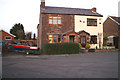
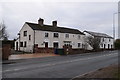
2
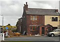
House on Hares Lane
Compare with Image from November 2005.
Image: © Gerald England
Taken: 10 Jul 2009
0.03 miles
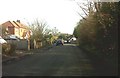
3
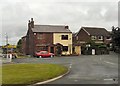
Snape Green
Houses at the corner of Hares Lane.
Image: © Gerald England
Taken: 16 Jul 2010
0.04 miles
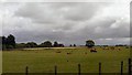
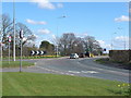
4
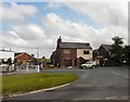
Snape Green
Off the A570 at Scarisbrick.
Image: © Gerald England
Taken: 10 Jul 2009
0.04 miles
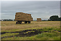
6
Carr Cross Cottage and House
Carr Cross House - the distant half - bears the date 1794.
Image: © Keith Edkins
Taken: 8 Mar 2018
0.05 miles