IMAGES TAKEN NEAR TO
Sefton Street, SOUTHPORT, PR8 5DB
Introduction
This page details the photographs taken nearby to Sefton Street, PR8 5DB by members of the Geograph project.
The Geograph project started in 2005 with the aim of publishing, organising and preserving representative images for every square kilometre of Great Britain, Ireland and the Isle of Man.

There are currently over 7.5m images from over14,400 individuals and you can help contribute to the project by visiting https://www.geograph.org.uk
Image Map (Loading...)


Getting Data...Please wait
Leaflet Map data © OpenStreetMap
Images are licensed for reuse under creativecommons.org/licenses/by-sa/2.0
Notes
- Clicking on the map will re-center to the selected point.
- The higher the marker number, the further away the image location is from the centre of the postcode.
Image Listing (15 Images Found)
Images are licensed for reuse under creativecommons.org/licenses/by-sa/2.0
Image
Details
Distance
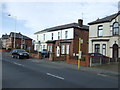
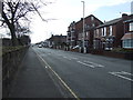
3
Duke Street
Part of an area of Southport with the streets in grid pattern.
Image: © Bill Boaden
Taken: 13 Sep 2019
0.14 miles
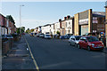
4

Lattimer Engineering, Shakespeare Street, Southport
Image: © Robert Wade
Taken: 17 Oct 2008
0.15 miles
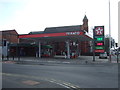
5
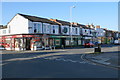
British Lawnmower Museum
Unfortunately not open when I passed.
Image: © Bill Boaden
Taken: 13 Sep 2019
0.18 miles
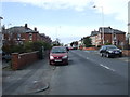
9
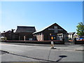
Scarisbrick New Road Baptist Church
Corner of Scarisbrick New Road and Southbank Road.
Image: © John Topping
Taken: 25 May 2013
0.23 miles
10
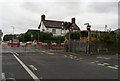
Level crossing at Duke Street, after a Southport-bound train has crossed
Image: © David Long
Taken: 25 Sep 2009
0.23 miles