IMAGES TAKEN NEAR TO
Duke Street, SOUTHPORT, PR8 5BZ
Introduction
This page details the photographs taken nearby to Duke Street, PR8 5BZ by members of the Geograph project.
The Geograph project started in 2005 with the aim of publishing, organising and preserving representative images for every square kilometre of Great Britain, Ireland and the Isle of Man.

There are currently over 7.5m images from over14,400 individuals and you can help contribute to the project by visiting https://www.geograph.org.uk
Image Map
Images are licensed for reuse under creativecommons.org/licenses/by-sa/2.0
Notes
- Clicking on the map will re-center to the selected point.
- The higher the marker number, the further away the image location is from the centre of the postcode.
Image Listing (17 Images Found)
Images are licensed for reuse under creativecommons.org/licenses/by-sa/2.0
Image
Details
Distance
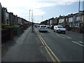
4
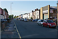
Duke Street
Part of an area of Southport with the streets in grid pattern.
Image: © Bill Boaden
Taken: 13 Sep 2019
0.16 miles
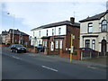
5
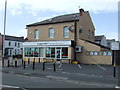
Post Office and supermarket
Off Cemetery Road.
Image: © JThomas
Taken: 15 Mar 2014
0.16 miles