IMAGES TAKEN NEAR TO
Walmer Road, SOUTHPORT, PR8 4ST
Introduction
This page details the photographs taken nearby to Walmer Road, PR8 4ST by members of the Geograph project.
The Geograph project started in 2005 with the aim of publishing, organising and preserving representative images for every square kilometre of Great Britain, Ireland and the Isle of Man.

There are currently over 7.5m images from over14,400 individuals and you can help contribute to the project by visiting https://www.geograph.org.uk
Image Map
Images are licensed for reuse under creativecommons.org/licenses/by-sa/2.0
Notes
- Clicking on the map will re-center to the selected point.
- The higher the marker number, the further away the image location is from the centre of the postcode.
Image Listing (21 Images Found)
Images are licensed for reuse under creativecommons.org/licenses/by-sa/2.0
Image
Details
Distance
3
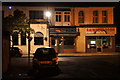
Liverpool Road, Birkdale
Looking towards Liverpool
Image: © Robert Wade
Taken: 11 Jul 2009
0.13 miles
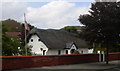
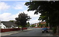
4

Thatched cottage, Liverpool Road, Birkdale
Image: © Mike Pennington
Taken: 10 Jul 2016
0.14 miles
6
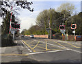
Crescent Road Level Crossing
Level crossing on the Southport to Liverpool railway line, between Birkdale and Ainsdale stations. The road on this side of the crossing is Crescent Road; its name changes to Grosvenor Road on the far side of the crossing.
Image: © David Dixon
Taken: 9 Apr 2011
0.17 miles
7
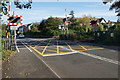
Level crossing on Grosvenor Road
Crossing the railway line between Southport and Liverpool.
Image: © Bill Boaden
Taken: 13 Sep 2019
0.17 miles
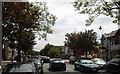
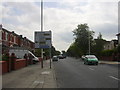
10
Shops on Liverpool Road, Birkdale
Taken from Welbeck Road.
Image: © Mike Pennington
Taken: 31 Jul 2013
0.21 miles