IMAGES TAKEN NEAR TO
Cardigan Road, SOUTHPORT, PR8 4SF
Introduction
This page details the photographs taken nearby to Cardigan Road, PR8 4SF by members of the Geograph project.
The Geograph project started in 2005 with the aim of publishing, organising and preserving representative images for every square kilometre of Great Britain, Ireland and the Isle of Man.

There are currently over 7.5m images from over14,400 individuals and you can help contribute to the project by visiting https://www.geograph.org.uk
Image Map
Images are licensed for reuse under creativecommons.org/licenses/by-sa/2.0
Notes
- Clicking on the map will re-center to the selected point.
- The higher the marker number, the further away the image location is from the centre of the postcode.
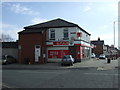
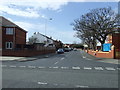
Image Listing (18 Images Found)
Images are licensed for reuse under creativecommons.org/licenses/by-sa/2.0
Image
Details
Distance
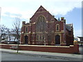
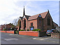
2
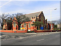
Liverpool Road Methodist Church, Birkdale
Image: © Mike Pennington
Taken: 5 Jul 2015
0.09 miles
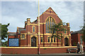
4
Liverpool Road Methodist Church, Birkdale
Image: © David Dixon
Taken: 9 Apr 2011
0.09 miles
5
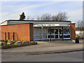
Birkdale Library
Birkdale library, on Liverpool Road
Image: © David Dixon
Taken: 9 Apr 2011
0.09 miles
7
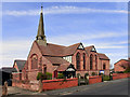
The Parish Church of St John, Birkdale
St John's Parish Church, on St John's Road at Birkdale.
Image: © David Dixon
Taken: 9 Apr 2011
0.14 miles
8
St John's Church, Birkdale
The Parish Church of St John, on St John's Road, Birkdale.
Image: © David Dixon
Taken: 9 Apr 2011
0.14 miles
9
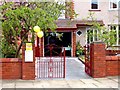
23 Ashton Road Birkdale
The garden at this house was open under the National Garden Scheme.
http://www.ngs.org.uk/ This garden was 1 of 6 open on the day
Image: © Norman Caesar
Taken: 8 May 2016
0.15 miles