IMAGES TAKEN NEAR TO
Benthams Way, SOUTHPORT, PR8 4HX
Introduction
This page details the photographs taken nearby to Benthams Way, PR8 4HX by members of the Geograph project.
The Geograph project started in 2005 with the aim of publishing, organising and preserving representative images for every square kilometre of Great Britain, Ireland and the Isle of Man.

There are currently over 7.5m images from over14,400 individuals and you can help contribute to the project by visiting https://www.geograph.org.uk
Image Map
Images are licensed for reuse under creativecommons.org/licenses/by-sa/2.0
Notes
- Clicking on the map will re-center to the selected point.
- The higher the marker number, the further away the image location is from the centre of the postcode.
Image Listing (3 Images Found)
Images are licensed for reuse under creativecommons.org/licenses/by-sa/2.0
Image
Details
Distance
1
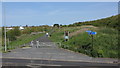
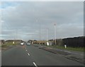
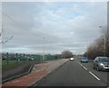
The former Town Lane Landfill Site
The area has been transformed by the creation of community woodland by the Forestry Commission as part of the Newlands Project.
Newlands is a NWDA-funded regeneration scheme, which is regenerating over 800 Hectares of the Northwest’s brownfield land to stimulate economic growth and further opportunities for leisure and environmental improvements.
Newlands, which stands for New Economic Environments via Woodlands, is a partnership scheme involving the NWDA and the Forestry Commission.
Image: © K A
Taken: 5 May 2012
0.11 miles