IMAGES TAKEN NEAR TO
Station Road, SOUTHPORT, PR8 3HS
Introduction
This page details the photographs taken nearby to Station Road, PR8 3HS by members of the Geograph project.
The Geograph project started in 2005 with the aim of publishing, organising and preserving representative images for every square kilometre of Great Britain, Ireland and the Isle of Man.

There are currently over 7.5m images from over14,400 individuals and you can help contribute to the project by visiting https://www.geograph.org.uk
Image Map
Images are licensed for reuse under creativecommons.org/licenses/by-sa/2.0
Notes
- Clicking on the map will re-center to the selected point.
- The higher the marker number, the further away the image location is from the centre of the postcode.
Image Listing (18 Images Found)
Images are licensed for reuse under creativecommons.org/licenses/by-sa/2.0
Image
Details
Distance
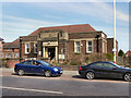
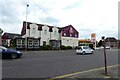
1
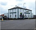
Champs Sports Bar and Grill
An American style sports bar in what was formerly The Railway Hotel which dates back to 1891.
Image: © Gerald England
Taken: 15 May 2022
0.02 miles
2
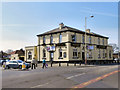
The Railway
The Railway public house on Station Road, Ainsdale.
Image: © David Dixon
Taken: 9 Apr 2011
0.03 miles
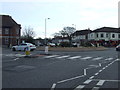
5
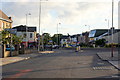
Shops around the Liverpool Road roundabout, Ainsdale
Image: © Mike Pennington
Taken: 5 Jul 2015
0.09 miles
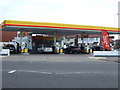
8
Toby Carvery
Liverpool Road, Ainsdale.
Image: © Gerald England
Taken: 15 May 2022
0.12 miles