IMAGES TAKEN NEAR TO
St. Thomas More Drive, SOUTHPORT, PR8 3FG
Introduction
This page details the photographs taken nearby to St. Thomas More Drive, PR8 3FG by members of the Geograph project.
The Geograph project started in 2005 with the aim of publishing, organising and preserving representative images for every square kilometre of Great Britain, Ireland and the Isle of Man.

There are currently over 7.5m images from over14,400 individuals and you can help contribute to the project by visiting https://www.geograph.org.uk
Image Map (Loading...)


Getting Data...Please wait
Leaflet Map data © OpenStreetMap
Images are licensed for reuse under creativecommons.org/licenses/by-sa/2.0
Notes
- Clicking on the map will re-center to the selected point.
- The higher the marker number, the further away the image location is from the centre of the postcode.
Image Listing (31 Images Found)
Images are licensed for reuse under creativecommons.org/licenses/by-sa/2.0
Image
Details
Distance
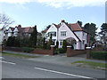
3
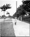
Liverpool Road before the War
A view of Liverpool Road from 1939. The photo was labelled as such: for the centisquare I am presuming this is outside or near to the photographer's house.
Photo taken by the contributor's grandfather, scanned and cropped from a 3x2 inch print.
Image: © Ted Flitcroft
Taken: Unknown
0.11 miles