IMAGES TAKEN NEAR TO
Liverpool Road, SOUTHPORT, PR8 3BZ
Introduction
This page details the photographs taken nearby to Liverpool Road, PR8 3BZ by members of the Geograph project.
The Geograph project started in 2005 with the aim of publishing, organising and preserving representative images for every square kilometre of Great Britain, Ireland and the Isle of Man.

There are currently over 7.5m images from over14,400 individuals and you can help contribute to the project by visiting https://www.geograph.org.uk
Image Map
Images are licensed for reuse under creativecommons.org/licenses/by-sa/2.0
Notes
- Clicking on the map will re-center to the selected point.
- The higher the marker number, the further away the image location is from the centre of the postcode.
Image Listing (18 Images Found)
Images are licensed for reuse under creativecommons.org/licenses/by-sa/2.0
Image
Details
Distance
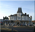
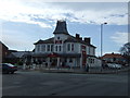
4
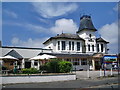
The Crown, Liverpool Road, Southport
Image: © Alexander P Kapp
Taken: 6 Jun 2008
0.11 miles
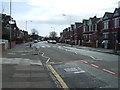
6
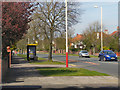
Waterloo Road, Birkdale
The A565, Waterloo Road, between Ainsdale and Birkdale.
Image: © David Dixon
Taken: 9 Apr 2011
0.17 miles
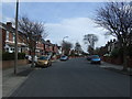
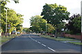
9
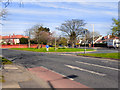
Liverpool Road - Waterloo Road Junction
The junction of Liverpool Road (A5267) and Waterloo Road (A565) in Birkdale.
Image: © David Dixon
Taken: 9 Apr 2011
0.20 miles
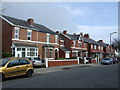
10
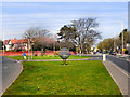
Birkdale - Road Junction
The junction of Liverpool Road (A5267) and Waterloo Road (A565) in Birkdale, with a giant golf ball sculpture on the central reservation.
Image: © David Dixon
Taken: 9 Apr 2011
0.21 miles