IMAGES TAKEN NEAR TO
Dunbar Crescent, SOUTHPORT, PR8 3AA
Introduction
This page details the photographs taken nearby to Dunbar Crescent, PR8 3AA by members of the Geograph project.
The Geograph project started in 2005 with the aim of publishing, organising and preserving representative images for every square kilometre of Great Britain, Ireland and the Isle of Man.

There are currently over 7.5m images from over14,400 individuals and you can help contribute to the project by visiting https://www.geograph.org.uk
Image Map (Loading...)


Getting Data...Please wait
Leaflet Map data © OpenStreetMap
Images are licensed for reuse under creativecommons.org/licenses/by-sa/2.0
Notes
- Clicking on the map will re-center to the selected point.
- The higher the marker number, the further away the image location is from the centre of the postcode.
Image Listing (17 Images Found)
Images are licensed for reuse under creativecommons.org/licenses/by-sa/2.0
Image
Details
Distance
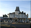
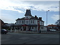
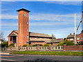
2
The Crown, Liverpool Road, Southport
Image: © Alexander P Kapp
Taken: 6 Jun 2008
0.09 miles
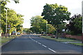
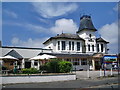
7
Waterloo Road, Hillside
Looking towards Our Lady of Lourdes Catholic church and Hillside railway station.
Image: © Nigel Thompson
Taken: 15 Feb 2023
0.17 miles
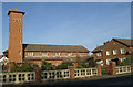
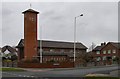
9
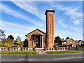
Our Lady of Lourdes Catholic Church, Hillside
Image: © David Dixon
Taken: 9 Apr 2011
0.18 miles