IMAGES TAKEN NEAR TO
Waterloo Road, SOUTHPORT, PR8 2NW
Introduction
This page details the photographs taken nearby to Waterloo Road, PR8 2NW by members of the Geograph project.
The Geograph project started in 2005 with the aim of publishing, organising and preserving representative images for every square kilometre of Great Britain, Ireland and the Isle of Man.

There are currently over 7.5m images from over14,400 individuals and you can help contribute to the project by visiting https://www.geograph.org.uk
Image Map
Images are licensed for reuse under creativecommons.org/licenses/by-sa/2.0
Notes
- Clicking on the map will re-center to the selected point.
- The higher the marker number, the further away the image location is from the centre of the postcode.
Image Listing (32 Images Found)
Images are licensed for reuse under creativecommons.org/licenses/by-sa/2.0
Image
Details
Distance
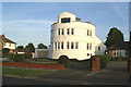
1
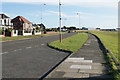
Waterloo Road
The A565 passing through Hillside, a suburb of Southport.
Image: © Bill Boaden
Taken: 13 Sep 2019
0.12 miles
2
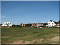
White houses near Royal Birkdale Golf Club (A565)
Two white houses on the A565 road adjacent to Royal Birkdale Golf Club, taken from the "Round Hill" sandhill area. SD3214
Image: © iamthehughes
Taken: 24 Apr 2011
0.13 miles
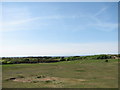
3
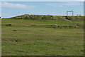
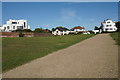
Round Hill
A hill 18 metres above sea level which is still a feature on this open green space.
Image: © Bill Boaden
Taken: 13 Sep 2019
0.14 miles
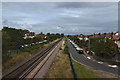
4
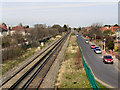
Railway at Hillside
Looking north east (towards Southport) along the Liverpool to Southport railway line; from Waterloo Road at Hillside Station.
Image: © David Dixon
Taken: 9 Apr 2011
0.14 miles
7
The Round Hill, Hillside (adjacent to Royal Birkdale Golf Club)
The Round Hill (a sandhill) at Hillside, Southport. Sand dunes and coastline visible on horizon.
Image: © iamthehughes
Taken: 24 Apr 2011
0.15 miles
8
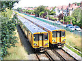
Merseyrail trains passing at Hillside
The two apparently identical trains are of different numbered classes (508 and 507).
The road alongside the railway to the right is Dover Road, and out of sight behind the bushes to the left is its twin, Cromer Road. The old-fashioned lamp-posts are just as they were when my grandfather took me here to look at the trains in the 1960s.
Image: © Stephen Craven
Taken: 5 Aug 2005
0.16 miles
9
Path at Hillside
A couple of art deco houses overlook the open space.
Image: © Bill Boaden
Taken: 13 Sep 2019
0.17 miles
10
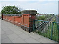
Wellington Road bridge opposite Hillside Station
The parapet of Wellington Road bridge opposite Hillside Station. There is an Ordnance Survey benchmark on the nearest buttress Image
BMD log: https://www.bench-marks.org.uk/bm180074
Image: © John S Turner
Taken: 22 Apr 2011
0.18 miles