IMAGES TAKEN NEAR TO
Sandringham Road, SOUTHPORT, PR8 2JZ
Introduction
This page details the photographs taken nearby to Sandringham Road, PR8 2JZ by members of the Geograph project.
The Geograph project started in 2005 with the aim of publishing, organising and preserving representative images for every square kilometre of Great Britain, Ireland and the Isle of Man.

There are currently over 7.5m images from over14,400 individuals and you can help contribute to the project by visiting https://www.geograph.org.uk
Image Map (Loading...)


Getting Data...Please wait
Leaflet Map data © OpenStreetMap
Images are licensed for reuse under creativecommons.org/licenses/by-sa/2.0
Notes
- Clicking on the map will re-center to the selected point.
- The higher the marker number, the further away the image location is from the centre of the postcode.
Image Listing (7 Images Found)
Images are licensed for reuse under creativecommons.org/licenses/by-sa/2.0
Image
Details
Distance
2
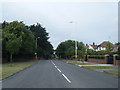
Gainsborough Road
A residential street leading from Waterloo Road to Southport & Birkdale Sports Club.
Image: © Bill Boaden
Taken: 13 Sep 2019
0.16 miles
3
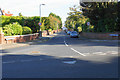
Sculpted hedges near Birkdale
On the corner of Selworthy Road and Waterloo Road.
Image: © Bill Boaden
Taken: 13 Sep 2019
0.16 miles
4
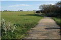
Path towards Greenbank High School
The school is visible in the distance. Royal Birkdale Golf Club is behind the foliage to the right. The large area of open space is popular with dog-walkers.
Image: © Bill Boaden
Taken: 13 Sep 2019
0.21 miles
5
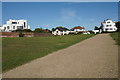
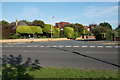
Path at Hillside
A couple of art deco houses overlook the open space.
Image: © Bill Boaden
Taken: 13 Sep 2019
0.25 miles
6
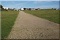
Path at Hillside
Ahead is the Round House, a reasonably famous art deco house.
Image: © Bill Boaden
Taken: 13 Sep 2019
0.25 miles
7
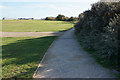
Path at Hillside
Crossing open space with Greenbank High School visible ahead.
Image: © Bill Boaden
Taken: 13 Sep 2019
0.25 miles