IMAGES TAKEN NEAR TO
Lulworth Road, SOUTHPORT, PR8 2AW
Introduction
This page details the photographs taken nearby to Lulworth Road, PR8 2AW by members of the Geograph project.
The Geograph project started in 2005 with the aim of publishing, organising and preserving representative images for every square kilometre of Great Britain, Ireland and the Isle of Man.

There are currently over 7.5m images from over14,400 individuals and you can help contribute to the project by visiting https://www.geograph.org.uk
Image Map (Loading...)


Getting Data...Please wait
Leaflet Map data © OpenStreetMap
Images are licensed for reuse under creativecommons.org/licenses/by-sa/2.0
Notes
- Clicking on the map will re-center to the selected point.
- The higher the marker number, the further away the image location is from the centre of the postcode.
Image Listing (12 Images Found)
Images are licensed for reuse under creativecommons.org/licenses/by-sa/2.0
Image
Details
Distance
1
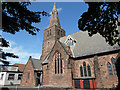
St James Church, Lulworth Road, Birkdale
Image: © Gary Rogers
Taken: 29 Aug 2015
0.13 miles
2
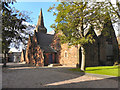
St James' Church, Birkdale
Lulworth Road, Birkdale.
Image: © David Dixon
Taken: 25 Sep 2010
0.13 miles
3
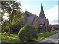
St James' Church, Lulworth Road, Birkdale
Image: © David Dixon
Taken: 25 Sep 2010
0.13 miles
4
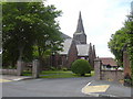
St James C Of E Church, 26 Lulworth Road, Birkdale, Southport
Image: © Robert Wade
Taken: 11 Jul 2009
0.14 miles
5
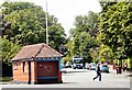
Cannot Spend a Penny Here
At the corner of Westcliffe Road and Lulworth Road is a set of public conveniences inconveniently boarded up.
Image: © Gerald England
Taken: 10 Jul 2009
0.17 miles
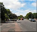
6
Victorian building for sale or redevelopment
At junction of Lulworth Road and Lord Street West
Image: © Gary Rogers
Taken: 29 Aug 2015
0.18 miles
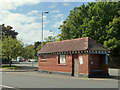
7
The End of Lord Street West
Here Lord Street West changes into Lulworth Road as the A565 to Liverpool bends to the left. On the right is Westcliffe Road.
Image: © Gerald England
Taken: 10 Jul 2009
0.18 miles
8
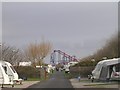
Southport Caravan Club Site
Looking in direction of pleasure beach. The pathway crossing the site road leads to Victoria Park on the right and the beach on the left
Image: © David Grimshaw
Taken: 24 Mar 2005
0.19 miles
9
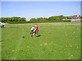
Victoria Park, Southport.
View North. Victoria Park location for annual 'Southport Flower Show'. Marine Way Bridge visible in distance.
Image: © Mark Arrowsmith
Taken: Unknown
0.19 miles
10
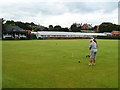
Southport & Birkdale Croquet Club
Croquet has been played here in Victoria Park since 1896.
Image: © John M
Taken: 22 Aug 2017
0.22 miles