IMAGES TAKEN NEAR TO
Coronation Walk, SOUTHPORT, PR8 1RD
Introduction
This page details the photographs taken nearby to Coronation Walk, PR8 1RD by members of the Geograph project.
The Geograph project started in 2005 with the aim of publishing, organising and preserving representative images for every square kilometre of Great Britain, Ireland and the Isle of Man.

There are currently over 7.5m images from over14,400 individuals and you can help contribute to the project by visiting https://www.geograph.org.uk
Image Map
Images are licensed for reuse under creativecommons.org/licenses/by-sa/2.0
Notes
- Clicking on the map will re-center to the selected point.
- The higher the marker number, the further away the image location is from the centre of the postcode.
Image Listing (193 Images Found)
Images are licensed for reuse under creativecommons.org/licenses/by-sa/2.0
Image
Details
Distance
2
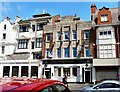
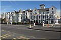
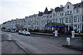
Pavilion Buildings, Southport
At the corner of Lord Street and Coronation Walk.
Image: © Gerald England
Taken: 10 Jul 2009
0.04 miles
3
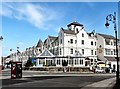
Royal Clifton Hotel
At the corner of the Promenade and Coronation Walk.
Image: © Gerald England
Taken: 10 Jul 2009
0.05 miles
4
Lord Street, Southport
Wikipedia http://en.wikipedia.org/wiki/Southport
Image: © Jeff Buck
Taken: 18 Jul 2013
0.05 miles
5
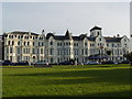
Royal Clifton Hotel
Royal Clifton Hotel as seen from Kings gardens.
Image: © Paul Rudge
Taken: 17 Feb 2007
0.06 miles
6
The Henry Segrave on Lord Street
The Henry Segrave is a Wetherspoon pub.
Image: © Steve Daniels
Taken: 5 Jun 2018
0.06 miles
7
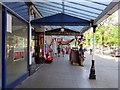
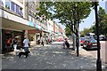
Veranda outside the shops on Lord Street
Image: © Steve Daniels
Taken: 5 Jun 2018
0.06 miles
8
Royal Clifton Hotel
A Victorian building with an amalgam of styles facing Princes Park.
Image: © Bill Boaden
Taken: 13 Sep 2019
0.07 miles
9
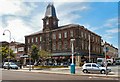
The Royal Clifton Hotel
Vast promenade premises operated by Best Western. Construction started in 1853; the Royal and Clifton were originally separate hotels. Grade II listed.
Image: © Keith Edkins
Taken: 11 Mar 2018
0.07 miles
10
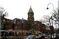
Southport (Lord Street) station
When the Southport and Cheshire Lines Extension Railway built its terminus in 1884, it did so on a grandiose scale, determined to outdo the rival Lancashire & Yorkshire terminus at Chapel Street. Not only was the SCELR station to be on Lord Street (the premier shopping street of the town) but it would have an overall glazed roof, five platforms, and an imposing frontage with a clock tower. However, the LYR had more routes than the SCELR, and Lord Street remained as not much more than an expensive curiosity, its finest hour coming in 1941 when the LYR line was temporarily disabled by enemy action.
After 1948, British Railways took a long and unsentimental look at Lord Street and in 1952 decided to close it. The station became a bus station, retaining its overall roof and little altered except for levelling of the platform area. Then in 1987 the bus station in its turn was closed, the overall roof demolished, and a Morrison's store built on the space. However, at the same time, the frontage was restored and remains intact today.
Image: © Dr Neil Clifton
Taken: 21 Mar 2009
0.07 miles