IMAGES TAKEN NEAR TO
Broadstone Drive, CHORLEY, PR7 7BE
Introduction
This page details the photographs taken nearby to Broadstone Drive, PR7 7BE by members of the Geograph project.
The Geograph project started in 2005 with the aim of publishing, organising and preserving representative images for every square kilometre of Great Britain, Ireland and the Isle of Man.

There are currently over 7.5m images from over14,400 individuals and you can help contribute to the project by visiting https://www.geograph.org.uk
Image Map
Images are licensed for reuse under creativecommons.org/licenses/by-sa/2.0
Notes
- Clicking on the map will re-center to the selected point.
- The higher the marker number, the further away the image location is from the centre of the postcode.
Image Listing (20 Images Found)
Images are licensed for reuse under creativecommons.org/licenses/by-sa/2.0
Image
Details
Distance
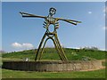
1
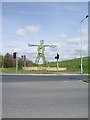
It reminds me of the "Wicker Man"
Statue at the northern entrance to Buckshaw Village
Image: © Alexander P Kapp
Taken: 17 Apr 2007
0.16 miles
2
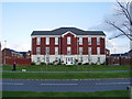
Apartments on Durham Drive, Buckshaw Village
Image: © Alexander P Kapp
Taken: 21 Oct 2008
0.17 miles
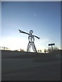
4
The Buckshaw Man
A 6m high tubular steel sculpture, located on the approach to Buckshaw Village, which is built on the previous Ordnance Factory Site, with public open space behind.
Image: © Philip Wallbank
Taken: 18 Apr 2009
0.18 miles
5

Buckshaw Man Sculpture
A 6-metre tall sculpture (reminiscent of "The Wicker Man") at the junction of Dawson Lane and Central Avenue at the entrance to the Buckshaw Village development.
Image: © David Dixon
Taken: 8 Jul 2012
0.19 miles
7
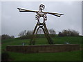
The Green Man, Buckshaw Village
Commissioned by a developer partnership for a 400 acre residential development, Buckshaw Village and erected in 2005. Stands 9m tall and made from tubular steel clad in fibre glass.
Image: © JThomas
Taken: 22 Nov 2014
0.20 miles
8

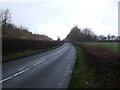
Dawson Lane, heading east to Whittle-le-Woods
Image: © Ann Cook
Taken: 4 Aug 2010
0.20 miles
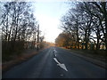
9
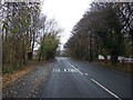
Dawson Lane (B5248)
Heading west towards Leyland.
Image: © JThomas
Taken: 22 Nov 2014
0.20 miles