IMAGES TAKEN NEAR TO
Euxton Lane, CHORLEY, PR7 6TB
Introduction
This page details the photographs taken nearby to Euxton Lane, PR7 6TB by members of the Geograph project.
The Geograph project started in 2005 with the aim of publishing, organising and preserving representative images for every square kilometre of Great Britain, Ireland and the Isle of Man.

There are currently over 7.5m images from over14,400 individuals and you can help contribute to the project by visiting https://www.geograph.org.uk
Image Map
Images are licensed for reuse under creativecommons.org/licenses/by-sa/2.0
Notes
- Clicking on the map will re-center to the selected point.
- The higher the marker number, the further away the image location is from the centre of the postcode.
Image Listing (15 Images Found)
Images are licensed for reuse under creativecommons.org/licenses/by-sa/2.0
Image
Details
Distance
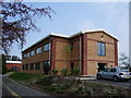
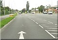
2

Investment House
One of the many Office blocks being built on the old Euxton munitions works
Image: © Alexander P Kapp
Taken: 17 Apr 2007
0.08 miles
3
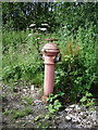
Fire hydrant
A left over from when the business park was the Royal Ordnance Factory
Image: © Alexander P Kapp
Taken: 1 Jul 2007
0.09 miles
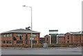
4
Office Block
The Ordnance Survey Office for Lancashire and Cumbria
Image: © Alexander P Kapp
Taken: 27 Apr 2007
0.10 miles
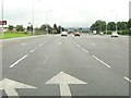
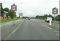
7
Traffic lights on Euxton Lane
The turning to the right leads to Buckshaw village.
Image: © Ann Cook
Taken: 11 Aug 2010
0.15 miles
9
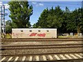
Graffiti on the railway
On the Blackpool line near Euxton.
Image: © philandju
Taken: 12 Jul 2017
0.17 miles
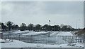
10
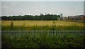
New housing development site, Buckshaw Village
Currently an open space, but the local master plan showes this area is to be developed as housing. Seen from the railway line to the south.
Image: © Richard Sutcliffe
Taken: 20 Jun 2017
0.19 miles