IMAGES TAKEN NEAR TO
Mallom Avenue, CHORLEY, PR7 6PU
Introduction
This page details the photographs taken nearby to Mallom Avenue, PR7 6PU by members of the Geograph project.
The Geograph project started in 2005 with the aim of publishing, organising and preserving representative images for every square kilometre of Great Britain, Ireland and the Isle of Man.

There are currently over 7.5m images from over14,400 individuals and you can help contribute to the project by visiting https://www.geograph.org.uk
Image Map (Loading...)


Getting Data...Please wait
Leaflet Map data © OpenStreetMap
Images are licensed for reuse under creativecommons.org/licenses/by-sa/2.0
Notes
- Clicking on the map will re-center to the selected point.
- The higher the marker number, the further away the image location is from the centre of the postcode.
Image Listing (14 Images Found)
Images are licensed for reuse under creativecommons.org/licenses/by-sa/2.0
Image
Details
Distance
1
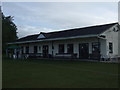
Euxton Cricket Club - Pavilion
Euxton Cricket Club play in the Manchester & District Cricket Association.
This is an early morning picture of the clubhouse at their Balshaw Park ground.
Image: © BatAndBall
Taken: 13 May 2011
0.08 miles
2
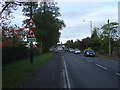
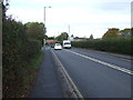
Balshaw Lane (A581)
Heading west towards Southport.
Image: © JThomas
Taken: 11 Oct 2014
0.11 miles
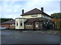
9
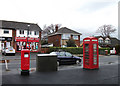
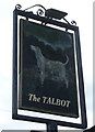
Talbot Drive, Euxton
Postbox and red telephone box outside the post office (and Spar shop) on the corner of Talbot Drive and Balshaw Lane (A581).
Image: © michael ely
Taken: 2 Apr 2011
0.17 miles
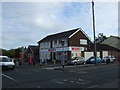
10
Balshaw Lane (A581)
Heading north west towards Southport.
Image: © JThomas
Taken: 11 Oct 2014
0.19 miles