IMAGES TAKEN NEAR TO
New Lane, CHORLEY, PR7 6NB
Introduction
This page details the photographs taken nearby to New Lane, PR7 6NB by members of the Geograph project.
The Geograph project started in 2005 with the aim of publishing, organising and preserving representative images for every square kilometre of Great Britain, Ireland and the Isle of Man.

There are currently over 7.5m images from over14,400 individuals and you can help contribute to the project by visiting https://www.geograph.org.uk
Image Map
Images are licensed for reuse under creativecommons.org/licenses/by-sa/2.0
Notes
- Clicking on the map will re-center to the selected point.
- The higher the marker number, the further away the image location is from the centre of the postcode.
Image Listing (17 Images Found)
Images are licensed for reuse under creativecommons.org/licenses/by-sa/2.0
Image
Details
Distance
1
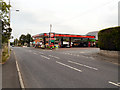
Texaco Filling Station, Ulnes Walton
Image: © Alexander P Kapp
Taken: 22 Feb 2011
0.03 miles
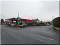
2
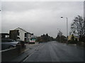
Texaco Garage, Ulnes Walton
The Texaco filling station at the corner of New Lane and Southport Road (A581).
Image: © David Dixon
Taken: 11 Aug 2012
0.04 miles
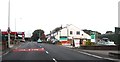
3
Entrance to the Rose and Crown, Southport Road
This is the A581. The entrance to the Rose and Crown is on the left. New Lane is on the right with a Texaco garage immediately afterwards.
Image: © Ann Cook
Taken: 26 Aug 2010
0.05 miles
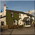
6
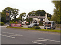
Rose and Crown
The Rose and Crown pub/restaurant on Southport Road (A581).
Image: © David Dixon
Taken: 11 Aug 2012
0.07 miles
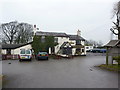
7
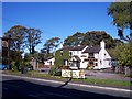
The Rose and Crown on Southport Road
Image: © Raymond Knapman
Taken: 20 Oct 2010
0.07 miles