IMAGES TAKEN NEAR TO
Badgers Walk, CHORLEY, PR7 6FH
Introduction
This page details the photographs taken nearby to Badgers Walk, PR7 6FH by members of the Geograph project.
The Geograph project started in 2005 with the aim of publishing, organising and preserving representative images for every square kilometre of Great Britain, Ireland and the Isle of Man.

There are currently over 7.5m images from over14,400 individuals and you can help contribute to the project by visiting https://www.geograph.org.uk
Image Map
Images are licensed for reuse under creativecommons.org/licenses/by-sa/2.0
Notes
- Clicking on the map will re-center to the selected point.
- The higher the marker number, the further away the image location is from the centre of the postcode.
Image Listing (10 Images Found)
Images are licensed for reuse under creativecommons.org/licenses/by-sa/2.0
Image
Details
Distance

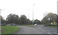
![Euxton Lane [B5252]](https://s0.geograph.org.uk/geophotos/02/29/60/2296052_3d28d994_120x120.jpg)
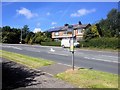
5
A roundabout - the turn for Astley Village
Image: © Ian Greig
Taken: 12 Jan 2013
0.16 miles
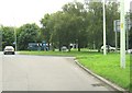
6
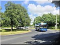
Roundabout on Euxton Lane
BMC Hawk (MP56 BUS), carrying the livery of the AVA Coach company negotiates one of the roundabouts on the Chorley West Bypass.
Image: © David Dixon
Taken: 11 Jun 2014
0.17 miles
7
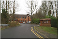
Derian House
Children's Hospice well supported in Wigan and district
Image: © David Long
Taken: 7 Feb 2006
0.17 miles
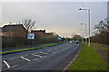
8
Roundabout on the B5252
This view is taken from Euxton Lane.
Image: © Ann Cook
Taken: 11 Aug 2010
0.18 miles
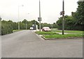
10
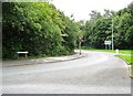
Chancery Road leading to Astley Village
This view is taken from the roundabout at the junction with Euxton Lane.
Image: © Ann Cook
Taken: 11 Aug 2010
0.22 miles