IMAGES TAKEN NEAR TO
Bentley Lane, CHORLEY, PR7 5UY
Introduction
This page details the photographs taken nearby to Bentley Lane, PR7 5UY by members of the Geograph project.
The Geograph project started in 2005 with the aim of publishing, organising and preserving representative images for every square kilometre of Great Britain, Ireland and the Isle of Man.

There are currently over 7.5m images from over14,400 individuals and you can help contribute to the project by visiting https://www.geograph.org.uk
Image Map
Images are licensed for reuse under creativecommons.org/licenses/by-sa/2.0
Notes
- Clicking on the map will re-center to the selected point.
- The higher the marker number, the further away the image location is from the centre of the postcode.
Image Listing (13 Images Found)
Images are licensed for reuse under creativecommons.org/licenses/by-sa/2.0
Image
Details
Distance
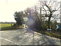
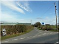
1
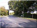
Barmskin Lane is joined by Bentley Lane
Bentley Lane on the left leads to Mawdesley
Image: © Raymond Knapman
Taken: 13 Oct 2010
0.09 miles
2
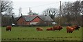
Highland Cattle in Lowland Lancashire
Image: © Anthony Parkes
Taken: 15 Mar 2014
0.09 miles
3
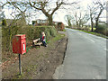
Postbox and bench on Barmskin Lane, Heskin
Image: © Gary Rogers
Taken: 7 Mar 2015
0.09 miles
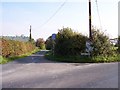
4
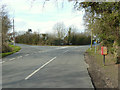
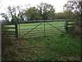
Junction of Barmskin Lane and Bentley Lane, Heskin
Image: © Gary Rogers
Taken: 7 Mar 2015
0.10 miles
5
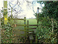
Stile at start of footpath between Barmskin Lane and Town Lane, Heskin
Image: © Gary Rogers
Taken: 7 Mar 2015
0.10 miles
6
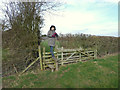
Stile between Howe Brook and Barmskin Lane, Heskin
Image: © Gary Rogers
Taken: 7 Mar 2015
0.15 miles
7
Junction of Barmskin Lane and Cooper's Lane, Heskin
Image: © Gary Rogers
Taken: 7 Mar 2015
0.15 miles
8
Junction of Barmskin Lane with Town Lane near Cragg's Farm
Image: © Gary Rogers
Taken: 7 Mar 2015
0.21 miles
9
Town Lane joins Barmskin Lane at Andertons Mill
Town Lane leads to Heskin Green
Image: © Raymond Knapman
Taken: 13 Oct 2010
0.22 miles