IMAGES TAKEN NEAR TO
The Warings, CHORLEY, PR7 5NZ
Introduction
This page details the photographs taken nearby to The Warings, PR7 5NZ by members of the Geograph project.
The Geograph project started in 2005 with the aim of publishing, organising and preserving representative images for every square kilometre of Great Britain, Ireland and the Isle of Man.

There are currently over 7.5m images from over14,400 individuals and you can help contribute to the project by visiting https://www.geograph.org.uk
Image Map
Images are licensed for reuse under creativecommons.org/licenses/by-sa/2.0
Notes
- Clicking on the map will re-center to the selected point.
- The higher the marker number, the further away the image location is from the centre of the postcode.
Image Listing (16 Images Found)
Images are licensed for reuse under creativecommons.org/licenses/by-sa/2.0
Image
Details
Distance
3
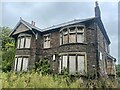
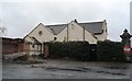
Grand house - 1920 style - abandoned
Picture taken this week August 2022 this grand house stands alone with extensive land to the side of the property. Such a shame as this is a beautiful property both inside and out.
Image: © OMG EXPLORING
Taken: Unknown
0.13 miles
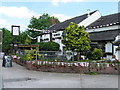

10
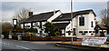
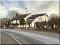
The Farmers Arms
Consistently a contender for best steak in the North West
Image: © Ian Greig
Taken: 13 Dec 2009
0.16 miles