IMAGES TAKEN NEAR TO
Wood Lane, CHORLEY, PR7 5NS
Introduction
This page details the photographs taken nearby to Wood Lane, PR7 5NS by members of the Geograph project.
The Geograph project started in 2005 with the aim of publishing, organising and preserving representative images for every square kilometre of Great Britain, Ireland and the Isle of Man.

There are currently over 7.5m images from over14,400 individuals and you can help contribute to the project by visiting https://www.geograph.org.uk
Image Map
Images are licensed for reuse under creativecommons.org/licenses/by-sa/2.0
Notes
- Clicking on the map will re-center to the selected point.
- The higher the marker number, the further away the image location is from the centre of the postcode.
Image Listing (24 Images Found)
Images are licensed for reuse under creativecommons.org/licenses/by-sa/2.0
Image
Details
Distance
3
Footpath between Wood Lane and Withington Lane at Barlow's Farm
Image: © Gary Rogers
Taken: 7 Mar 2015
0.05 miles
4
Footbridge over drain near Barlow's Farm, Heskin
Image: © Gary Rogers
Taken: 7 Mar 2015
0.05 miles

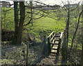
6

Stile on Wood Lane, Heskin
At the Wood Lane end of the public footpath between Wood Lane and Town Lane
Image: © Gary Rogers
Taken: 7 Mar 2015
0.11 miles
7

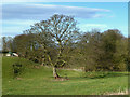
Pond in field West of Wood Lane near The Meadows estate
Image: © Gary Rogers
Taken: 7 Mar 2015
0.13 miles
8

Milestone, Heskin Green
Milestone on Wood Lane B5250, visible in Image
Note the bench mark. See http://www.bench-marks.org.uk/bm44727 .
Image: © Ian Taylor
Taken: 14 Aug 2012
0.13 miles
9

Eleven miles to Preston
And OS cut mark on roadside marker on Wood Lane, Heskin
Image: © Gary Rogers
Taken: 7 Mar 2015
0.14 miles
10

Old Milestone by the B5250, Wood Lane, Heskin Green
Metal plate attached to stone post by the B5250, in parish of HESKIN (CHORLEY District), Heskin Green, in pavement outside No. 179 Wood Lane, on East side of road. Preston iron plate, erected by the Penwortham & Wrightington turnpike trust in the 19th century.
Inscription reads:-
TO
PRESTON
11
MILES.
Carved benchmark on lower face.
Milestone Society National ID: LA_PSWG11.
Image: © C Marcus
Taken: 1 Apr 2008
0.14 miles