IMAGES TAKEN NEAR TO
Rivington Place, CHORLEY, PR7 5DY
Introduction
This page details the photographs taken nearby to Rivington Place, PR7 5DY by members of the Geograph project.
The Geograph project started in 2005 with the aim of publishing, organising and preserving representative images for every square kilometre of Great Britain, Ireland and the Isle of Man.

There are currently over 7.5m images from over14,400 individuals and you can help contribute to the project by visiting https://www.geograph.org.uk
Image Map
Images are licensed for reuse under creativecommons.org/licenses/by-sa/2.0
Notes
- Clicking on the map will re-center to the selected point.
- The higher the marker number, the further away the image location is from the centre of the postcode.
Image Listing (25 Images Found)
Images are licensed for reuse under creativecommons.org/licenses/by-sa/2.0
Image
Details
Distance

5
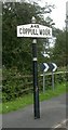
Village Signpost by the A49, Preston Road
Pawn finial - 1 arm; Lancashire village entry sign by the A49, in parish of Coppull (Chorley District), Coppull Moor, South of village, West side of road. Set in pavement in photo, but appears to have been set further back after 2016.
Surveyed
Milestone Society National ID: LA_SD5512
Image: © Milestone Society
Taken: Unknown
0.09 miles
7
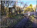
Gate and Marker Post, Chisnall Hall Nature Reserve
The Chisnall Hall former colliery site covers 55 hectares, close to Coppull Moor and adjacent to the M6. It is being reclaimed to create an extensive native community woodland across the site with up to 65,000 trees (https://www.lep.co.uk/lifestyle/nature-reserve-for-colliery-site-1-5245680 Lancashire Post).
See Image] for a closer look at the stone marker.
Image: © David Dixon
Taken: 2 Feb 2018
0.09 miles
8
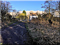
Chisnall Hall Nature Reserve
Path leading onto the A49, Preston Road. The Chisnall Hall former colliery site covers 55 hectares, close to Coppull Moor and adjacent to the M6. It is being reclaimed to create an extensive native community woodland across the site with up to 65,000 trees (https://www.lep.co.uk/lifestyle/nature-reserve-for-colliery-site-1-5245680 Lancashire Post).
Image: © David Dixon
Taken: 2 Feb 2018
0.10 miles
9
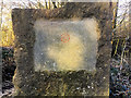
Stone Marker Post, Chisnall Hall Nature Reserve
The Chisnall Hall former colliery site covers 55 hectares, close to Coppull Moor and adjacent to the M6. It is being reclaimed to create an extensive native community woodland across the site with up to 65,000 trees (https://www.lep.co.uk/lifestyle/nature-reserve-for-colliery-site-1-5245680 Lancashire Post). This stone is next to the gate at Preston Road. It reads:
This stone marks 40 years of land reclamation by
LANCASHIRE COUNTY COUNCIL
1954-1994
It stands at the entrance to the former
CHISNALL HALL COLLIERY
The site was reclaimed in 1976 by the County Council.
Unveiled 25th June 1994 by County Councillor Mrs Louise Ellman
Leader of Lancashire County Council
See Image] for a wider view.
Image: © David Dixon
Taken: 2 Feb 2018
0.10 miles