IMAGES TAKEN NEAR TO
Spendmore Lane, CHORLEY, PR7 5DE
Introduction
This page details the photographs taken nearby to Spendmore Lane, PR7 5DE by members of the Geograph project.
The Geograph project started in 2005 with the aim of publishing, organising and preserving representative images for every square kilometre of Great Britain, Ireland and the Isle of Man.

There are currently over 7.5m images from over14,400 individuals and you can help contribute to the project by visiting https://www.geograph.org.uk
Image Map
Images are licensed for reuse under creativecommons.org/licenses/by-sa/2.0
Notes
- Clicking on the map will re-center to the selected point.
- The higher the marker number, the further away the image location is from the centre of the postcode.
Image Listing (25 Images Found)
Images are licensed for reuse under creativecommons.org/licenses/by-sa/2.0
Image
Details
Distance
1
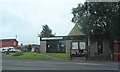
Coppull Conservative Club, Spendmore Lane
Image: © David Dixon
Taken: 17 Apr 2014
0.03 miles
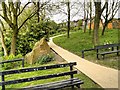
5
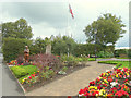
Garden of Remembrance, Spendmore Lane, Coppull
Image: © Gary Rogers
Taken: 18 Sep 2015
0.09 miles
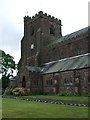
6
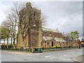
St John's Church, Coppull
The Church of St John the Divine at Coppull is a Grade II listed building (English Heritage Building ID: 357607 http://www.britishlistedbuildings.co.uk/en-357607-church-of-st-john-the-divine-coppull-lan British Listed Buildings). It dates from 1911.
Image: © David Dixon
Taken: 17 Apr 2014
0.11 miles