IMAGES TAKEN NEAR TO
Mill Street, CHORLEY, PR7 5AZ
Introduction
This page details the photographs taken nearby to Mill Street, PR7 5AZ by members of the Geograph project.
The Geograph project started in 2005 with the aim of publishing, organising and preserving representative images for every square kilometre of Great Britain, Ireland and the Isle of Man.

There are currently over 7.5m images from over14,400 individuals and you can help contribute to the project by visiting https://www.geograph.org.uk
Image Map
Images are licensed for reuse under creativecommons.org/licenses/by-sa/2.0
Notes
- Clicking on the map will re-center to the selected point.
- The higher the marker number, the further away the image location is from the centre of the postcode.
Image Listing (22 Images Found)
Images are licensed for reuse under creativecommons.org/licenses/by-sa/2.0
Image
Details
Distance
1
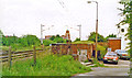
Site of Coppull station, WCML 1994
View northward, towards Preston, Lancaster, Carlisle etc.: ex-London North Western, West Coast Main Line, closed 6/10/69, prior to electrification in 1974.
Image: © Ben Brooksbank
Taken: 18 Jun 1994
0.04 miles
4
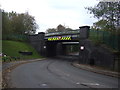
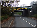
Railway bridge over Spendmore Lane
Looking north east.
Image: © JThomas
Taken: 25 Oct 2014
0.12 miles
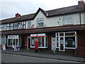
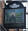
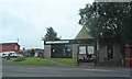
6
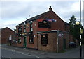
The Springfield pub, Coppull
On Spendmore Lane.
Image: © JThomas
Taken: 25 Oct 2014
0.18 miles
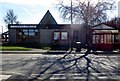
10
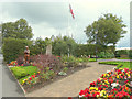
Garden of Remembrance, Spendmore Lane, Coppull
Image: © Gary Rogers
Taken: 18 Sep 2015
0.21 miles