IMAGES TAKEN NEAR TO
Chapel Way, CHORLEY, PR7 4QN
Introduction
This page details the photographs taken nearby to Chapel Way, PR7 4QN by members of the Geograph project.
The Geograph project started in 2005 with the aim of publishing, organising and preserving representative images for every square kilometre of Great Britain, Ireland and the Isle of Man.

There are currently over 7.5m images from over14,400 individuals and you can help contribute to the project by visiting https://www.geograph.org.uk
Image Map
Images are licensed for reuse under creativecommons.org/licenses/by-sa/2.0
Notes
- Clicking on the map will re-center to the selected point.
- The higher the marker number, the further away the image location is from the centre of the postcode.
Image Listing (6 Images Found)
Images are licensed for reuse under creativecommons.org/licenses/by-sa/2.0
Image
Details
Distance
1
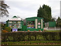
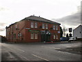
www.discover.co.uk
The place where you can buy everything for the great outdoors including the caravan.
(Update: Site redeveloped and website defunct 2021)
Image: © Alexander P Kapp
Taken: 2 Jan 2009
0.07 miles
2
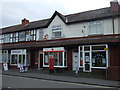
Eastham's Toffee Shop and Ice Cream Parlour
Image: © Alexander P Kapp
Taken: 2 Jan 2009
0.11 miles
5
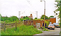
Site of Coppull station, WCML 1994
View northward, towards Preston, Lancaster, Carlisle etc.: ex-London North Western, West Coast Main Line, closed 6/10/69, prior to electrification in 1974.
Image: © Ben Brooksbank
Taken: 18 Jun 1994
0.23 miles