IMAGES TAKEN NEAR TO
Claytongate, CHORLEY, PR7 4PR
Introduction
This page details the photographs taken nearby to Claytongate, PR7 4PR by members of the Geograph project.
The Geograph project started in 2005 with the aim of publishing, organising and preserving representative images for every square kilometre of Great Britain, Ireland and the Isle of Man.

There are currently over 7.5m images from over14,400 individuals and you can help contribute to the project by visiting https://www.geograph.org.uk
Image Map
Images are licensed for reuse under creativecommons.org/licenses/by-sa/2.0
Notes
- Clicking on the map will re-center to the selected point.
- The higher the marker number, the further away the image location is from the centre of the postcode.
Image Listing (29 Images Found)
Images are licensed for reuse under creativecommons.org/licenses/by-sa/2.0
Image
Details
Distance
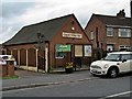
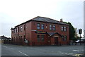
2
Village Hall
New house on the site of the old Village Hall.
Image: © Peter McDermott
Taken: 7 Jul 2023
0.06 miles
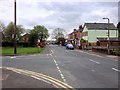
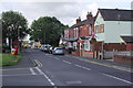
3
Chapel Lane and the junction with Sunny Brow
Image: © Ann Cook
Taken: 5 Sep 2010
0.08 miles
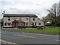
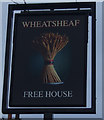
5
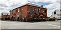
Wheatsheaf Hotel
The Wheatsheaf Hotel public house.
Image: © Peter McDermott
Taken: 7 Jul 2023
0.09 miles
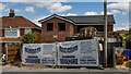
8
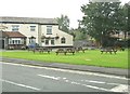
Picnic area in front of the Printers Arms
The road in the foreground is Coppull Hall Lane.
Image: © Ann Cook
Taken: 5 Sep 2010
0.13 miles
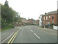
9
Chapel Lane, Coppull
Seen from the junction with Coppull Hall Lane. There were still a few flags in evidence from the Diamond Jubilee Celebrations
Image: © K A
Taken: 21 Jul 2012
0.13 miles