IMAGES TAKEN NEAR TO
Holt Avenue, CHORLEY, PR7 4PD
Introduction
This page details the photographs taken nearby to Holt Avenue, PR7 4PD by members of the Geograph project.
The Geograph project started in 2005 with the aim of publishing, organising and preserving representative images for every square kilometre of Great Britain, Ireland and the Isle of Man.

There are currently over 7.5m images from over14,400 individuals and you can help contribute to the project by visiting https://www.geograph.org.uk
Image Map
Images are licensed for reuse under creativecommons.org/licenses/by-sa/2.0
Notes
- Clicking on the map will re-center to the selected point.
- The higher the marker number, the further away the image location is from the centre of the postcode.
Image Listing (12 Images Found)
Images are licensed for reuse under creativecommons.org/licenses/by-sa/2.0
Image
Details
Distance
1
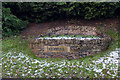
One of a pair of flower beds which appear to serve as boundary markers for Coppull
Image: © Ian Greig
Taken: 17 Dec 2011
0.04 miles
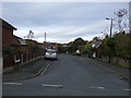
5
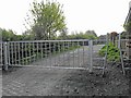
Birkacre Brow Gate
New gate for Birkacre Rucks and Yarrow Valley Park - also private access road for the houses.
Image: © C-A-F-G Winder
Taken: 23 Apr 2009
0.08 miles
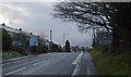
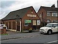
7
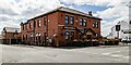
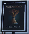
Wheatsheaf Hotel
The Wheatsheaf Hotel public house.
Image: © Peter McDermott
Taken: 7 Jul 2023
0.09 miles
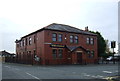
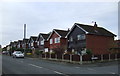
10
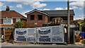
Village Hall
New house on the site of the old Village Hall.
Image: © Peter McDermott
Taken: 7 Jul 2023
0.22 miles