IMAGES TAKEN NEAR TO
Wigan Lane, CHORLEY, PR7 4BN
Introduction
This page details the photographs taken nearby to Wigan Lane, PR7 4BN by members of the Geograph project.
The Geograph project started in 2005 with the aim of publishing, organising and preserving representative images for every square kilometre of Great Britain, Ireland and the Isle of Man.

There are currently over 7.5m images from over14,400 individuals and you can help contribute to the project by visiting https://www.geograph.org.uk
Image Map
Images are licensed for reuse under creativecommons.org/licenses/by-sa/2.0
Notes
- Clicking on the map will re-center to the selected point.
- The higher the marker number, the further away the image location is from the centre of the postcode.
Image Listing (12 Images Found)
Images are licensed for reuse under creativecommons.org/licenses/by-sa/2.0
Image
Details
Distance
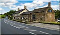
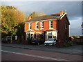
1
Thyme & Plaice Restaurant
On Wigan Lane (A5106).
Image: © JThomas
Taken: 25 Oct 2014
0.04 miles
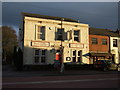
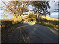
3

Wigan Lane (A5106)
Wigan Lane, at the junction with Jolly Tar Lane.
Image: © David Dixon
Taken: 25 Sep 2010
0.05 miles
4

Junction of Jolly Tar Lane and Wigan Lane, Adlington
Image: © Gary Rogers
Taken: 21 Jul 2015
0.05 miles
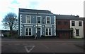
5
Thyme and Plaice restaurant, Wigan Road, Adlington
Image: © Gary Rogers
Taken: 21 Jul 2015
0.05 miles
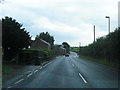
8
Wigan Lane (A5106)
Heading north east towards Chorley.
Image: © JThomas
Taken: 25 Oct 2014
0.12 miles
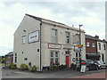
9
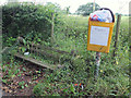
Keep Coppull Tidy
On Wigan Lane A5106 just north of Jolly Tar Lane
Image: © Gary Rogers
Taken: 21 Jul 2015
0.12 miles