IMAGES TAKEN NEAR TO
Scawfell Road, CHORLEY, PR7 2JL
Introduction
This page details the photographs taken nearby to Scawfell Road, PR7 2JL by members of the Geograph project.
The Geograph project started in 2005 with the aim of publishing, organising and preserving representative images for every square kilometre of Great Britain, Ireland and the Isle of Man.

There are currently over 7.5m images from over14,400 individuals and you can help contribute to the project by visiting https://www.geograph.org.uk
Image Map
Images are licensed for reuse under creativecommons.org/licenses/by-sa/2.0
Notes
- Clicking on the map will re-center to the selected point.
- The higher the marker number, the further away the image location is from the centre of the postcode.
Image Listing (25 Images Found)
Images are licensed for reuse under creativecommons.org/licenses/by-sa/2.0
Image
Details
Distance
1
Reminder of the old days
Proof that coal mining was a significant industry west of Chorley. On the B5251.
Image: © David Long
Taken: 7 Feb 2006
0.10 miles
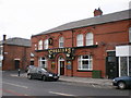
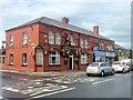
5
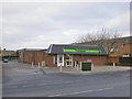
The Co-operative, Moor Road, Chorley
Image: © Alexander P Kapp
Taken: 2 Jan 2009
0.12 miles
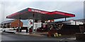
6
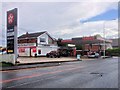
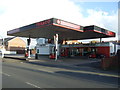
Costcutter and Texaco Filling Station on Moor Road, Chorley
Image: © David Dixon
Taken: 10 Jun 2014
0.12 miles
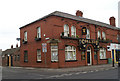
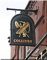
9
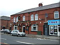
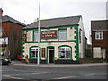
The Colliers, Moor Road
Traditional pub. The name probably refers to miners from the former Chorley Moor Colliery.
Image: © David Dixon
Taken: 10 Jun 2014
0.13 miles